Goudo Noroshidai: Difference between revisions
(Created page with "{{Castle |English Name=Goudo Noroshidai |Japanese Name=神戸烽火台 |Romaji Name=Gōdo-noroshidai |Founder=Takeda Shingen |Year Founded=16th Century |Castle Type=Mountaintop |Castle Condition=Ruins only |Historical Period=Pre Edo Period |Visitor Information=24/7 free; mountain |Time Required=10 minutes |City=Hokuto |Prefecture=Yamanashi Prefecture |Notes=Gōdo-noroshidai is a noroshidai (fortified beacon) site in Sutama Township, Hokuto Municipality. No ruins remain,...") |
No edit summary |
||
| Line 8: | Line 8: | ||
|Castle Condition=Ruins only | |Castle Condition=Ruins only | ||
|Historical Period=Pre Edo Period | |Historical Period=Pre Edo Period | ||
|Access=Access from north of mount | |||
|Visitor Information=24/7 free; mountain | |Visitor Information=24/7 free; mountain | ||
|Time Required=10 minutes | |Time Required=10 minutes | ||
| Line 13: | Line 14: | ||
|Prefecture=Yamanashi Prefecture | |Prefecture=Yamanashi Prefecture | ||
|Notes=Gōdo-noroshidai is a noroshidai (fortified beacon) site in Sutama Township, Hokuto Municipality. No ruins remain, and the hilltop is now the site of a cluster of hokora (mini-shrines) with a cleared space behind which might've been a small bailey or look-out. I visited this ruin as part of a tour of noroshidai in the area. There was a very light snowfall. | |Notes=Gōdo-noroshidai is a noroshidai (fortified beacon) site in Sutama Township, Hokuto Municipality. No ruins remain, and the hilltop is now the site of a cluster of hokora (mini-shrines) with a cleared space behind which might've been a small bailey or look-out. I visited this ruin as part of a tour of noroshidai in the area. There was a very light snowfall. | ||
|History=Gōdo-noroshidai was part of the network of beacons that linked Takeda territory in their homeland of Kai with their conquests in Shinano. Gōdo-noroshidai stood between the noroshidai of Wada-noroshidai to the north and Maenoyama-noroshidai to the south, the latter of which I visited next. The fort was also used to guard the Gōdo Pass. The village of Gōdo is directly below. | |History=Gōdo-noroshidai was part of the network of beacons that linked Takeda territory in their homeland of Kai with their conquests in Shinano. Gōdo-noroshidai stood between the noroshidai of Wada-noroshidai to the north and [[Maenoyama Noroshidai|Maenoyama-noroshidai]] to the south, the latter of which I visited next. The fort was also used to guard the Gōdo Pass. The village of Gōdo is directly below. | ||
|Year Visited=Viewer Contributed | |Year Visited=Viewer Contributed | ||
|AddedJcastle=2025 | |AddedJcastle=2025 | ||
Latest revision as of 09:17, 10 February 2025
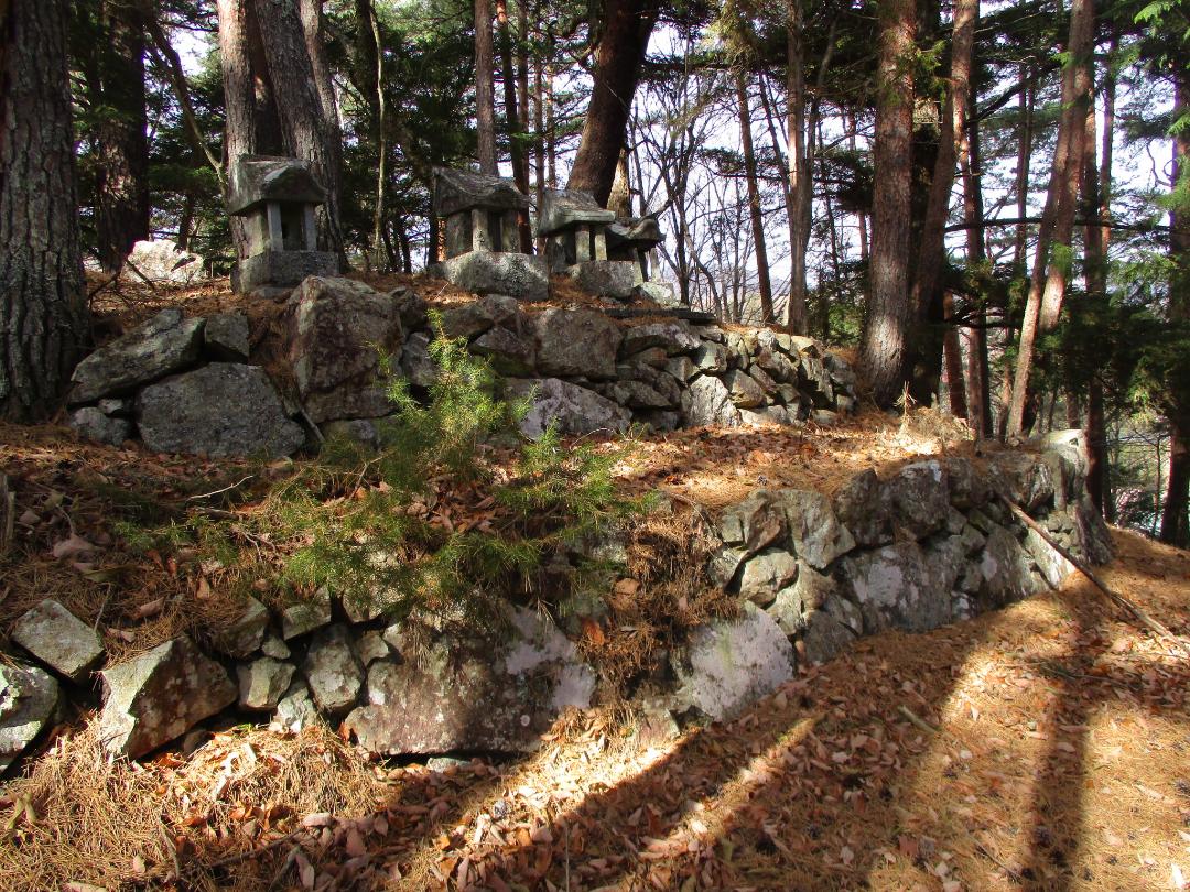
Gōdo-noroshidai is a noroshidai (fortified beacon) site in Sutama Township, Hokuto Municipality. No ruins remain, and the hilltop is now the site of a cluster of hokora (mini-shrines) with a cleared space behind which might've been a small bailey or look-out. I visited this ruin as part of a tour of
History
Gōdo-noroshidai was part of the network of beacons that linked Takeda territory in their homeland of Kai with their conquests in Shinano. Gōdo-noroshidai stood between the noroshidai of Wada-noroshidai to the north and Maenoyama-noroshidai to the south, the latter of which I visited next. The fort was also used to guard the Gōdo Pass. The village of Gōdo is directly below.
Field Notes
Gōdo-noroshidai is a noroshidai (fortified beacon) site in Sutama Township, Hokuto Municipality. No ruins remain, and the hilltop is now the site of a cluster of hokora (mini-shrines) with a cleared space behind which might've been a small bailey or look-out. I visited this ruin as part of a tour of noroshidai in the area. There was a very light snowfall.
| Castle Profile | |
|---|---|
| English Name | Goudo Noroshidai |
| Japanese Name | 神戸烽火台 |
| Founder | Takeda Shingen |
| Year Founded | 16th Century |
| Castle Type | Mountaintop |
| Castle Condition | Ruins only |
| Historical Period | Pre Edo Period |
| Features | |
| Visitor Information | |
| Access | Access from north of mount |
| Hours | 24/7 free; mountain |
| Time Required | 10 minutes |
| Location | Hokuto, Yamanashi Prefecture |
| Coordinates | 35.86711, 138.50399 |
|
|
|
| Admin | |
| Added to Jcastle | 2025 |
| Contributor | ART |
| Admin Year Visited | Viewer Contributed |
| Friends of JCastle | |
| Yogo | |


