Saimyoji Castle: Difference between revisions
No edit summary |
No edit summary |
||
| (6 intermediate revisions by 2 users not shown) | |||
| Line 14: | Line 14: | ||
|Visitor Information=24/7 free | |Visitor Information=24/7 free | ||
|Time Required=35 mins | |Time Required=35 mins | ||
|City=Mashiko | |City=Mashiko | ||
|Prefecture=Tochigi Prefecture | |Prefecture=Tochigi Prefecture | ||
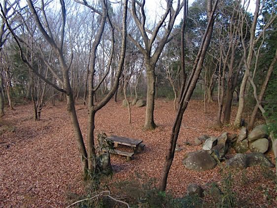
|Notes=I came to this site because I was visiting Saimyōji and happen to see it marked on my map. I climbed the mountain behind the temple and found only a single board (in Japanese only) about the castle, from which I gleaned its history. There are no sign posts indicating where the castle is and no markers indicating castle features at the site itself. Walking around I found the “shiroato hiroba” which I took for the honmaru. The honmaru atop the hill has a ring of deformed dorui (earthen embankments) surrounding it. There is at least one sub-bailey between the honmaru and the largest visibly remaining gate ruin. At the base of the hill is a trench, looks like a horikiri. Unfortunately it was a futile effort trying to photograph these details because young bamboo blanketed everything. Crossing the horikiri to climb to the main bailey we passed through a bamboo thicket. Luckily the honmaru is cleared except for a few trees and boulders. Only see this site if you visit Saimyōji. There is actually some old looking ishigaki beneath the pagoda (1536) at the temple. | |Notes=I came to this site because I was visiting Saimyōji and happen to see it marked on my map. I climbed the mountain behind the temple and found only a single board (in Japanese only) about the castle, from which I gleaned its history. There are no sign posts indicating where the castle is and no markers indicating castle features at the site itself. Walking around I found the “shiroato hiroba” which I took for the honmaru. The honmaru atop the hill has a ring of deformed dorui (earthen embankments) surrounding it. There is at least one sub-bailey between the honmaru and the largest visibly remaining gate ruin. At the base of the hill is a trench, looks like a horikiri. Unfortunately it was a futile effort trying to photograph these details because young bamboo blanketed everything. Crossing the horikiri to climb to the main bailey we passed through a bamboo thicket. Luckily the honmaru is cleared except for a few trees and boulders. Only see this site if you visit Saimyōji. There is actually some old looking ishigaki beneath the pagoda (1536) at the temple. | ||
<p>Profile and photos contributed by ART</p> | <p>Profile and photos contributed by ART</p> | ||
| Line 22: | Line 21: | ||
|Year Visited=Viewer Contributed | |Year Visited=Viewer Contributed | ||
|AddedJcastle=2017 | |AddedJcastle=2017 | ||
|GPSLocation=36.45439, 140.12053 | |||
|Contributor=ART | |||
|rating_average=0.5 | |rating_average=0.5 | ||
|castleElev=301 | |castleElev=301 | ||
Latest revision as of 07:16, 13 April 2023
I came to this site because I was visiting Saimyōji and happen to see it marked on my map. I climbed the mountain behind the temple and found only a single board (in Japanese only) about the castle, from which I gleaned its history. There are no sign posts indicating where the castle is and no marke
History
Originally called Takadateyamajō, the castle was the base of the Mashiko clan, originally called the Ki clan. The Mashiko went to war with the Utsunomiya clan during the Sengoku Period and were defeated, whereupon their mountaintop castle was abandoned.
Field Notes
I came to this site because I was visiting Saimyōji and happen to see it marked on my map. I climbed the mountain behind the temple and found only a single board (in Japanese only) about the castle, from which I gleaned its history. There are no sign posts indicating where the castle is and no markers indicating castle features at the site itself. Walking around I found the “shiroato hiroba” which I took for the honmaru. The honmaru atop the hill has a ring of deformed dorui (earthen embankments) surrounding it. There is at least one sub-bailey between the honmaru and the largest visibly remaining gate ruin. At the base of the hill is a trench, looks like a horikiri. Unfortunately it was a futile effort trying to photograph these details because young bamboo blanketed everything. Crossing the horikiri to climb to the main bailey we passed through a bamboo thicket. Luckily the honmaru is cleared except for a few trees and boulders. Only see this site if you visit Saimyōji. There is actually some old looking ishigaki beneath the pagoda (1536) at the temple.
Profile and photos contributed by ART
| Castle Profile | |
|---|---|
| English Name | Saimyoji Castle |
| Japanese Name | 西明寺城 |
| Alternate Names | Takadateyama-jo |
| Founder | Mashiko Clan |
| Year Founded | 1058-1065 |
| Castle Type | Mountaintop |
| Castle Condition | Ruins only |
| Designations | Local Historic Site |
| Historical Period | Pre Edo Period |
| Features | trenches |
| Visitor Information | |
| Access | Mashiko Station on the Moka Line; Taxi (I went by personal transportation) |
| Hours | 24/7 free |
| Time Required | 35 mins |
| Location | Mashiko, Tochigi Prefecture |
| Coordinates | 36.45439, 140.12053 |
|
|
|
| Admin | |
| Added to Jcastle | 2017 |
| Contributor | ART |
| Admin Year Visited | Viewer Contributed |


