Imai Jin'ya: Difference between revisions
No edit summary |
No edit summary |
||
| Line 3: | Line 3: | ||
|Japanese Name=今井陣屋 | |Japanese Name=今井陣屋 | ||
|Romaji Name=Imai Jin'ya | |Romaji Name=Imai Jin'ya | ||
|Alternate Names= | |||
|Founder=Tokugawa Shogunate | |Founder=Tokugawa Shogunate | ||
|Year Founded=1691 | |Year Founded=1691 | ||
| Line 8: | Line 9: | ||
|Castle Condition=Ruins only | |Castle Condition=Ruins only | ||
|Historical Period=Edo Period | |Historical Period=Edo Period | ||
|Main Keep Structure= | |||
|Year Reconstructed= | |||
|Artifacts= | |||
|Access= | |||
|Visitor Information=24/7 free | |Visitor Information=24/7 free | ||
|Time Required=5 minutes | |Time Required=5 minutes | ||
|Website= | |||
|City=Matsumoto | |City=Matsumoto | ||
|Prefecture=Nagano Prefecture | |Prefecture=Nagano Prefecture | ||
|Notes=The road adjacent to the temple is still referred to as "Jin'ya Road". I wouldn't probably have looked into Imai-jin'ya further except that I did find proof of its former existence in the form of a small, very new looking signpost marking its location. | |Notes=The road adjacent to the temple is still referred to as "Jin'ya Road". I wouldn't probably have looked into Imai-jin'ya further except that I did find proof of its former existence in the form of a small, very new looking signpost marking its location. | ||
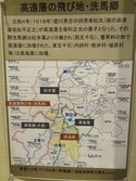
|History=The area used to be owned by Takatō-han but in 1691 it became part of a tenryō (Shogunal demesne) in the area with the reducation in territory of Takatō-han, and Imai-jin'ya was built at that time. Takatō-han was then made up of several tobichi (discontiguous territory). Imai-jin'ya was located in the tenryō which shares a border with Takatō-han (via Seba Village), Matsumoto-han, Owari-han and Takashima-han, so it was quite crowded in. Imai-jin'ya was basically a sort of minor ward office serving under | |History=The area used to be owned by Takatō-han but in 1691 it became part of a tenryō (Shogunal demesne) in the area with the reducation in territory of Takatō-han, and Imai-jin'ya was built at that time. Takatō-han was then made up of several tobichi (discontiguous territory). Imai-jin'ya was located in the tenryō which shares a border with Takatō-han (via Seba Village), Matsumoto-han, Owari-han and Takashima-han, so it was quite crowded in. Imai-jin'ya was basically a sort of minor ward office serving under Iijima-jin'ya. In 1713 the land was granted to the Mizuno Clan and Imai-jin'ya was abandoned. | ||
|Year Visited=Viewer Contributed | |Year Visited=Viewer Contributed | ||
|AddedJcastle=2019 | |AddedJcastle=2019 | ||
|Japanese Notes= | |||
|Visits= | |||
|GPSLocation=36.14638, 137.9046 | |GPSLocation=36.14638, 137.9046 | ||
|Contributor=ART | |Contributor=ART | ||
|FriendsLinks= | |||
}} | }} | ||
Latest revision as of 16:15, 19 October 2020
The road adjacent to the temple is still referred to as "Jin'ya Road". I wouldn't probably have looked into Imai-jin'ya further except that I did find proof of its former existence in the form of a small, very new looking signpost marking its location.
History
The area used to be owned by Takatō-han but in 1691 it became part of a tenryō (Shogunal demesne) in the area with the reducation in territory of Takatō-han, and Imai-jin'ya was built at that time. Takatō-han was then made up of several tobichi (discontiguous territory). Imai-jin'ya was located in the tenryō which shares a border with Takatō-han (via Seba Village), Matsumoto-han, Owari-han and Takashima-han, so it was quite crowded in. Imai-jin'ya was basically a sort of minor ward office serving under Iijima-jin'ya. In 1713 the land was granted to the Mizuno Clan and Imai-jin'ya was abandoned.
Field Notes
The road adjacent to the temple is still referred to as "Jin'ya Road". I wouldn't probably have looked into Imai-jin'ya further except that I did find proof of its former existence in the form of a small, very new looking signpost marking its location.
| Castle Profile | |
|---|---|
| English Name | Imai Jin'ya |
| Japanese Name | 今井陣屋 |
| Founder | Tokugawa Shogunate |
| Year Founded | 1691 |
| Castle Type | Flatland |
| Castle Condition | Ruins only |
| Historical Period | Edo Period |
| Features | |
| Visitor Information | |
| Access | |
| Hours | 24/7 free |
| Time Required | 5 minutes |
| Location | Matsumoto, Nagano Prefecture |
| Coordinates | 36.14638, 137.9046 |
|
|
|
| Admin | |
| Added to Jcastle | 2019 |
| Contributor | ART |
| Admin Year Visited | Viewer Contributed |


