Matsugashima Castle
Matsuǵashimajō is a hirajiro (flatland) castle ruin in Matsuǵashima Township, Matsusaka Municipality. Ruins remain on-site in the form of a grassy hillock which used to be the castle's tenshudai (platform for a donjon). Despite once being quite a vast fortress, very little remains of Matsuǵashimajō,
.jpg)
History
Matsuǵashimajō was a short-lived castle which existed from 1580 to 1588. It was constructed by Oda Nobukatsu in 1580, and used between the destruction by fire of Tamarujō in 1580 and the construction of Matsusakajō in 1588. The castle featured an impressive five-tier donjon.
In 1582, Oda Nobukatsu moved to Kiyosujō and left his vassal, Tsugawa Yoshifuyu, in charge of Matsuǵashimajō. In 1584, Tsugawa was up on treason charges, so Takigawa Katsutoshi took over as castellan of Matsuǵashimajō. That year, during the Komaki-Nagakute wars, Matsuǵashimajō, defended by about 3,000 men (including - some say- a hundred musketeers from Iga-Kōka under Hattori Hanzō), was besieged for over a month by Toyotomi forces numbering some 20,000. The battle was concluded diplomatically and Matsuǵashimajō was saved.
After the Battle of Komaki-Nagakute, Gamō Ujisato became castellan of Matsuǵashimajō. Matsuǵashimajō was located on a cape surrounded by coastal marshes. It was intended as an important strategic position controlling both land and sea. However, the terrain constrained development of a prosperous jōkamachi (castle-town), and so Gamō Ujisato built Matsusakajō to replace Matsuǵashimajō. Upon the completion of Matsusakajō, Matsuǵashimajō was abandoned.
Matsuǵashimajō may have been the site of an earlier fort called Hosokubijō ('Narrow Neck Castle'), built by Kitabatake Tomonori in 1567. That fort was destroyed in 1569 during Oda Nobunaga's invasion of Ise Province which led to the installment of Oda Nobukatsu.
Field Notes
Matsuǵashimajō is a hirajiro (flatland) castle ruin in Matsuǵashima Township, Matsusaka Municipality. Ruins remain on-site in the form of a grassy hillock which used to be the castle's tenshudai (platform for a donjon). Despite once being quite a vast fortress, very little remains of Matsuǵashimajō, abandoned in 1588, and the site is now fields. The tenshudai is maintained as a small park. It's strange to find this small park in the middle of rice paddies, accessed via dusty country roads. From atop of the tenshudai, toward dusk, I saw a fox bounding along the edge of a paddy.
A sea wall can be seen 400m to the north of the tenshudai, with fields all around. However, the sea used to come up to the castle itself. The main bailey extended north of the tenshudai, and there was a small, ellipitcal bailey beyond that separating the main bailey and the sea. There were several outer baileys in which the castle-town was constructed.
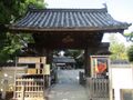
Local neighbourhood names such as 'South Bailey', 'Inner Castle', and 'Outer Castle' give a clue as to this once being a large fortification site. Besides from the tenshudai, which is on-site, several buildings exist which are said to have been relocated from the castle to various temples in Matsusaka. These include a gate at Ryūsenji, and a shoin (drawing room) at Keishōji (see sub-gallery below).
.jpg)
.jpg)
.jpg)
More Galleries and Feature Pages
(22 photos)
| Castle Profile | |
|---|---|
| English Name | Matsugashima Castle |
| Japanese Name | 松ヶ島城 |
| Alternate Names | Hosokubijō (細頸城) |
| Founder | Kitabatake Tomonori; Oda Nobukatsu |
| Year Founded | 1567; 1580 |
| Castle Type | Flatland |
| Castle Condition | Ruins only |
| Designations | Prefectural Historic Site |
| Historical Period | Pre Edo Period |
| Artifacts | Tenshudai |
| Features | |
| Visitor Information | |
| Access | Matsuǵasaki Station on the Kintetsu-Yamada Line; 25 minute walk |
| Hours | 24/7 free; fields |
| Time Required | 10 minutes |
| URL | Castle Website |
| Location | Matsusaka, Mie Prefecture |
| Coordinates | 34.60548, 136.53263 |
|
|
|
| Admin | |
| Added to Jcastle | 2024 |
| Contributor | ART |
| Admin Year Visited | Viewer Contributed |
| Friends of JCastle | |
| Jōkaku Hōrōki | |
| Kojōdan | |
| Oshiro Tabi Nikki | |
| Kojōshi | |
| Umoreta Kojō | |
| Yogo | |

