10 Kyoto Castles Update May 2025
This update brings 10 new castles from across Kyoto Prefecture, all loosely tied to the Tanba Campaigns and eventually falling to Akechi Mitsuhide during his push through the region. Kyoto isn’t often thought of as a top destination for castl'ing, but the city, its suburbs, and the outer edges of th
10 Kyoto Castles Update May 2025
2025-05-16
This update brings 10 new castles from across Kyoto Prefecture, all loosely tied to the Tanba Campaigns and eventually falling to Akechi Mitsuhide during his push through the region. Kyoto isn’t often thought of as a top destination for castl'ing, but the city, its suburbs, and the outer edges of the prefecture are full of hidden fortresses and overlooked sites that tell the story of Japan’s power struggles and shifting alliances in the late 1400s through the 1500s.
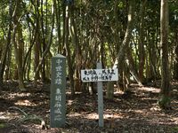
This update also adds four profiles (Shiogai Castle, Higashi Goma Castle, Obata Castle (Tanba), and Onigajo Castle) from the list of recommended castles from the Woodland Kyoto campaign. While these are sometimes difficult to access they are all well preserved and have features worth visiting.
Goma Nakamura Castle / 胡麻中村城
Higashi Goma Castle / 東胡麻城
Iden Castle / 位田城
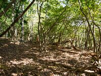
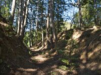
I’ve climbed some tough castle ruins before, but this one nearly broke me. The trail starts out well enough, but it quickly fades into a steep, overgrown mess from the "Jin'ya" bailey. It seems the path may have been maintained at some point, but that effort has long since lapsed. When trees are cleared and the shade disappears, weeds tend to take over the forest floor—obscuring not only the castle remains but also the trail itself. I could find no unejo tatebori and only 2 horikiri lower on the slope.
After "jin'ya" which is quite near the base, the trail ascends nearly 200 meters in elevation—and becomes almost impossible to follow. In the steeper sections, old ropes tied between trees were the only indication of where the path might be. I spent much of the climb clutching a rope with one hand (sometimes both) just to know where I was going through the weeds and and also using my trekking pole for balance on the slippery, steep slope.
By the time I reached the upper enclosure, I was exhausted and covered in dirt and spider webs wet from the morning dew clinging to the nearly shoulder high weeds that I had essentially “swum” through. I quickly gave up on reaching the lower peak, there were no ropes or clear trail in that direction, just another steep descent into an overgrown slope. On my way back down, I encountered another castle explorer who had turned back long before reaching the summit.
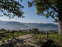
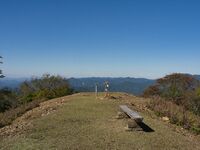
Despite the struggle, it wasn’t a total loss. At the peak, I was rewarded with a fading sea of clouds stretching across the valley below.
For a sizable castle, it's actually difficult to find much good information about this castle. I've relied on the Kyoto Prefecture Castle Survey and 近畿の名城 I and some history of the Iden area to put this together. Many other blogs and posts have somewhat incomplete or conflicting stories and there is a common error among them that says it was conquered by Akechi Mitsuhide in 1572, which is very unlikely. I would like to know the original source of that one! Tanba campaigns did not start until 1575, after Oda had solidified some control over Kyoto by defeating the Asakura/Azai and expelling Ashikaga Yoshiaki from Kyoto in 1573. Until then Oda was more occupied with Kyoto and Mitsuhide was still a rising star who was yet to take any other castles between Kyoto and Iden Castle.

Not to be used without permission.
Iden Miyanokoshi Castle / 位田宮越城

Not to be used without permission.
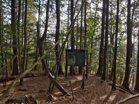
Noge Yakata / 野化館
Obata Castle (Tanba) / 小畑城
I had originally considered visiting another site after Obata, but the combination of a poor-quality rental bike, 20 km of cycling, unusually hot weather, and the long, slippery climb at Iden Castle earlier in the day nearly broke me!
Obata Castle is very well maintained. While I was there, a few volunteers were clearing fallen branches and weeding the paths in for an autumn cleaning. The castle itself is fairly compact—you could walk through it twice and still cover the whole site in under an hour. This modest size makes the infrequent bus service even harder to justify.
The main trail and central enclosure are well maintained, but if you climb over the rear earthen embankment (dorui) and descend into the horikiri, you’ll find a stunning trench. Just a bit farther downslope, there’s also a tatebori (vertical trench) you can view from above. These earthwork features are among the highlights of the site and worth exploring if you’re comfortable going slightly off the maintained trail.Onigajo Castle / 鬼ヶ城
This is a long steep hike, but the trail is clear and well marked making it a good trek. The trailhead begins at Kannonji Temple and diverges from a popular hiking route leading to Mt. Chōgatake, which may have hosted another satellite fortification. Originally, I planned to explore this area as well; however, despite the clear morning weather, afternoon rain clouds prompted a change in plans.
Access to Onigajō via public transportation is limited. The nearest option is a 5 km uphill walk from Gujo Station. I started here but treated myself to a taxi ride to reach the trailhead since it was my birthday. Despite providing detailed directions, the driver attempted to take me to a forestry road leading to an alternate trail he recalled from his school days, which would supposedly end up much closer to the summit than Kannonji Temple. Unfortunately, this trail appears to no longer exist, or the forestry road is inaccessible. The driver felt bad about the inconvenience and kindly offered a complimentary return ride to Fukuchiyama Station after my hike. Given the changing afternoon weather conditions, I very much appreciated the gesture.
History clarification: Some blog sources inaccurately state that Onigajō fell to Akechi Mitsuhide in 1575. However, Mitsuhide’s initial campaign in Tanba began in 1575 but did not reach Fukuchiyama until the second campaign in 1578–1579. Therefore, the fall of Onigajō is more accurately dated to 1579.

Not to be used without permission.
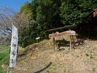
Shiogai Castle / 塩貝城
Shizuhara North Castle / 静原城(北城)
Shizuhara North Castle is located at the mountain summit and consists of terraced baileys along three ridgelines. There is minimal stonework: a possible gate foundation in the main bailey and one side bailey with stones that may have served as a retaining wall rather than fortifications. In contrast, the South Castle, which lies farther away than one might expect from maps, features extensive stonework, tatebori (vertical moats), and a prominent horikiri trench isolating it from the upper ridge — evidence of a later, more advanced fortification.
The trail begins to the left of Shizuhara Shrine and climbs steeply to the summit, reaching Shizuhara North Castle in about 45 minutes. While the path can be steep and is not well marked, it is generally clear and manageable without risk of getting lost.
See Shizuhara South Castle for more details.Shizuhara South Castle / 静原城(南城)
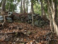
Shizuhara North Castle is located at the mountain summit and consists of terraced baileys along three ridgelines. There is minimal stonework: a possible gate foundation in the main bailey and one side bailey with stones that may have served as a retaining wall rather than fortifications. In contrast, the South Castle, which lies farther away than one might expect from maps, features extensive stonework, tatebori (vertical moats), and a prominent horikiri trench isolating it from the upper ridge — evidence of a later, more advanced fortification.
To reach the South Castle directly, you can climb the ridge from the base near Shizuhara village, but there is no marked trail. Even descending this way requires some navigation, and the path can be difficult to identify. If you’re already visiting the North Castle anyway, I would recommend to descend the eastern ridge to reach the South Castle.
Be advised: while the trail up to the North Castle is relatively clean and manageable, the descent toward the South Castle is overgrown, poorly marked, and scattered with fallen trees. You’ll need to scramble over or around these obstacles and watch the trees for ribbons indicating the path. That said, the South Castle’s ruins — with stone walls, vertical moats (tatebori), and a massive horikiri trench — make the effort worthwhile and it is much more interesting than the North Castle. You can also refer to my Yamap Trail log for navigation support.
See Shizuhara North Castle for more details.Recent News
Sep 28, 2025
Yagyu Castles, Chihaya Akasaka Forts, and Kaibara Jin'ya
Sep 20, 2025
ART added 33 new castles across central Japan
Jul 29, 2025
31 new profiles from ART for Gifu Prefecture
Jul 19, 2025
Battle of Shizugatake Feature + 17 new castles
Jul 8, 2025
34 new profiles from ART for Shizuoka and Yamanashi
Jun 7, 2025
Comment System Upgrade
May 24, 2025
Four new castles around Sasayama Hyogo
May 16, 2025
10 Kyoto Castles Update May 2025
Mar 23, 2025
Hagi Castle & Hagi Castle Town Project
Jan 23, 2025
Bitchu Matsuyama Castle and Ohmatsuyama Castle Updates
Jan 3, 2025
2024 Jcastle cleanup and Happy New Year 2025
Dec 10, 2024
Sayonara Google Maps
Dec 2, 2024
Tsuyama Castle Update and 500th Castle Visited
Nov 11, 2024
Jcastle Rebuild 2024
Oct 3, 2024
11 New Castles around Kyoto
Sep 30, 2024
ART's New Profiles for Aichi Prefecture
Sep 22, 2024
5 new Okinawa Castle Profiles
Jul 27, 2024
Mikazuki Jinya, Kohyama Castle, and updated Hikone Castle
Jul 22, 2024
28 new profiles from ART
Jul 7, 2024
5 Castles from Ayabe City in Kyoto