31 new profiles from ART for Gifu Prefecture
This update brings another 31 castles to Gifu Prefecture castles added by ART over the past few months. It's great to see the Akechi Castle and Akechi Jin'ya added to the Akechi lore of this area as well as some others like Bodaiyama Castle and Tama Castle (Mino) that had been o
31 new profiles from ART for Gifu Prefecture
2025-07-29
This update brings another 31 castles to Gifu Prefecture castles added by ART over the past few months. It's great to see the Akechi Castle and Akechi Jin'ya added to the Akechi lore of this area as well as some others like Bodaiyama Castle and Tama Castle (Mino) that had been on my "to do" list for a long time.
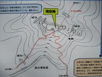
Akechi Castle / 明知城
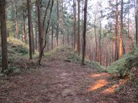
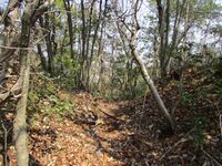
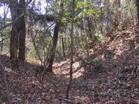
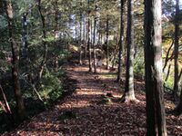
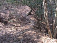
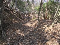
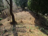
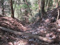
The castle further has many lower baileys and a large demaru (outer bailey). There is dorui around some of these baileys too, such as the 'north main bailey annex'. I entered the castle by attempting to follow a terraced ridge from the southwest. However, the trail that used to be there had been swallowed by overgrowth, and consequently I had to infiltrate the castle by navigating a large, deep trench complex. In descending I took the trail to the northwest which is beside a long, climbing segment of dorui which flanks the castle's original main approach.
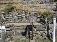
The Akechi-Tôyama Clan cenotaphs are found to the north at Ryūgoji where there is also, at the neighbouring Hachiōji-jinja, a gate which is said to have been originally built at the castle. The gate is a prefectural cultural property.
Akechijō is sometimes called Shiratakajō ('White Falcon Castle'), a sort of nickname. It may see common use due to there being several castle sites called 'Akechi', including Toki-Akechijō (also in Akechi Township, Ena Municipality) and Akechi-Osayamajō (also near an Akechi Station, but along the Meitetsu-Hiromi Line in Kani Municipality). Akechijō in historic Ena County is not to be confused with Akechi-Osayamajō in historic Kani County, both in Mino Province (Gifu Prefecture).Akechi Jin'ya / 明智陣屋
Bodaiyama Castle / 菩提山城
The trench on the main approach to the castle is spanned by a dobashi (earthen bridge). Karabori (dry moats) form an umadashi (barbican) approach into the main bailey. There is a deep horikiri between the third and outer baileys. Tatebori are found throughout this site, and they are nauseatingly steep and long.
The castle's deguruwa (projecting bailey) has unejōtatebori, a row of tatebori in close configuration, beneath it. These tatebori, of which there are three smaller trenches flanked by a large outer trench on each side of the ridge, begin from a terrace and connect just below with a large horikiri. This stalwart, array of trenches like spokes is one of several highlights of this site in my estimation.
The main bailey has a koshikuruwa (terraced bailey) beneath it in the west. A yokobori runs between the bottom of the earthen walls of the main bailey and the koshikuruwa. The use of yokobori is seen rarely at yamajiro, so it's always nice to see. Two tatebori hem in a series of small pocket baileys climbing like stairs down the mountainside to the west of the koshikuruwa. This is called the 'horse-slipping slope', and was intended to be a major impediment to cavalry charges up the slope. There is a tarmac / asphalt road at the bottom of here; this would definitely be a shortcut up to the castle for those averse to hiking (300m up), but I'm not sure if there's anywhere to park.
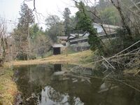
Bodaiyamajō has many features and is a top yamajiro in the Tōkai region. I had wanted to visit for several years after first visiting Takenaka-jin'ya, which is the former kyokan (residential compound) paired with the castle, in 2020; despite all that waiting I was not disappointed! By the way, Bodaiji means 'funerary temple' or 'clan temple'. The temple Bodaiji at the foot of the castle-mount was (re-)built by the Takenaka Clan at the start of the Edo period. Some of the buildings are cultural properties. The hike to the castle starts from here and takes up to an hour depending on one's pace.Dota Castle (Mino) / 美濃土田城
Fukigabora Castle / 吹ヶ洞城
Gongen'yama Castle (Mino) / 美濃権現山城
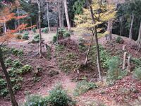
The south bailey group could be considered the lower castle, as it is somewhat smaller and lower down. It retains a nice section of dorui. The south bailey is also referred to as the demaru (projecting / outer bailey). Below it are indications of trenches.
The north bailey group has the honmaru (main bailey) where there is now a shrine building, Kinpu-jinja, and there are terraced baileys below it except in the north. The south terrace has dorui, including a dorui partition between the terraced baileys, which may have been a gate site. There are falling chute-like trenches in the east. The map I was using (Yogo's) didn't show it, but there was an eastern terrace and tatebori (climbing trench). The hill here is really steep, vertiginous in places, and the earth seems like it wants to collapse, so it's not a safe area.
The ishigaki (stone-pilings) seen on-site appears to be mostly related to the shrine and park, though some bits I found may be quite old. Now the site is maintained mostly as a park attached to the suburban housing estate to the south. Entering from this side the 50m tall castle-mount may not seem as impressive, but this area was probably mountainous in the past, and the castle facing the river below would've been intimidating from the north. The shrine's causeway is accessed from the northwest alongside the Kani River, and I came up this way after walking from Mitake Station. After visiting Gongen'yamajō I continued via the suburban development to the related site of Honjin'yamajō. These twin forts are known together as Mitakejō.Goudo Castle / 顔戸城
Although the site is a hirajiro in its layout and design, it does sit on a sort of plateau, and this difference in elevation to the south has determined the composition of its defences. The lower side of the fort, particularly the surviving portion of the southern perimeter to the southeast which has an outer array of dorui (earthen ramparts), has only very shallow dorui on the inside of the moat atop of the bailey parapet. In contrast, in the north of the ruin there is no outside dorui, but a mizubori (water moat) or numabori (swamp moat) with very tall and thick dorui on the inside. The inner dorui continues in the east and west, but it's very overgrown so I didn't walk the whole length.
I started my exploration by jumping into the southeastern portion of the karabori (dry moat), and climbing, because the moat slopes with the terrain, up to the northeast. Beyond that the moat becomes water-filled. I got out and followed the numabori along to where there were gaps in the northern embankments. I think one of these was probably a modern road built by removing the dorui, but there is a narrower one, too narrow for a car, which may have been a dobashi (earthen bridge) and castle's main entrance in the past. I got as close as I dared to the moat here, and my shiny new hiking boots got a baptism of fire - or mud, as it were. The northwestern portion of moat was so overgrown and coagulated that I couldn't even see inside it and daylight didn't penetrate. The interior of the bailey is now farmsteads, houses and fields.Honjin'yama Castle (Mino) / 美濃本陣山城・美濃御嵩城
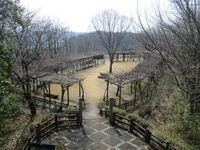
Maps suggest that Honjin'yamajō was made up of several baileys, with the peak bailey being the main bailey, but narrow, perhaps serving as a look-out. There are terraced baileys below along the vestigal ridges, and on the slope to the east. Beneath the uppermost bailey was a trench system with a dobashi (earthen bridge). These chutes are very overgrown now but can just be made out on the hillside. If the trench cut across the whole hilltop then it has now been filled in for the park. The large lower bailey may have served as the de facto main bailey, although it looks like it has also been altered and enlarged for the park. It has a cloister of wisteria pergolas surrounding it.
The castle-mount has been converted into a park, and parkland further expands below. If the castle's kyokan (residential annex) was here, then it would've been quite a large area, deserving of the designation 'Honjin'. However, it's impossible to know now just by looking what the original structure of the entire fort complex looked like. The suburban housing estates of Nanzandai West and Nanzandai East are divided by the castle-mount. I came to Honjin'yamajō via Nanzandai-higashi from Gongen-yamajō. This meant I didn't have to climb from the very bottom of the hill, but the stairway up from Nanzandai-higashi were nonetheless a lot to do at a dash! I descended via Nanzandai-nishi and went back to Mitake Station, completing my walking circuit of the two sites.Hourinji Castle / 法林寺城
Ibi Castle / 揖斐城
Ikoyama Castle / 祐向城
Along the ridge between Ikoyamajō and neighbouring Kakeborajō, I found a very steep creek with mounding on one side, which made me think it may have been a tatebori (climbing trench) or an augmented and fortified natural feature. It was hard to imagine the creek being formed naturally, but I am not an expert on how geological forces stitch mountains together; anyway, it was not a feature depicted on any of the maps I had.
Ikoyamajō sits between Kakeborajō and Hōrinjijō in the Monjuyama fort group (the peak of Monjuyama is the site of Yamaguchijō). I approached Ikoyamajō from Kakeborajō before proceeding onto Hōrinjijō since the fort group forms a circuit upon the mountains around the valley where Hōrinji village is. I completed an unclosed loop, starting at Motosu Station and finishing at Oribe Station, the next station along on the Tarumi Railway.Imasu Castle (Mino) / 美濃今須城
Kakebora Castle / 掛洞城
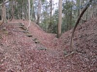
My favourite feature was the ladder of terraced baileys beneath the main bailey, bordered by a very prominent tatebori and climbing berm. The castle features many terraces (so that I am quite sure I missed some), and the topmost bailey groups along the ridge are divided by horikiri. The western bailey has prominent dorui embanked facing southward.
Kakeborajō was my first and main target in a hiking circuit covering fortification sites on Mount Monju and associated peaks. I started from Motosu Station and climbed the trail from Monju Park hidden behind the Hachiman shrine. This trail was quite long, but it allowed me to hike in a loop without doubling back. Eventually that trail reaches the mountaintop where Kakeborajō is located. Thereafter a series of ups-and-downs took me through the sites of Ikoyamajō, Hōrinjijō, Yamaguchijō (the peak of Mount Monju) and Nakanojō. Together, these sites are referred to as the 'Monjuyama Jōsaigun (Fortress Complex of Mount Monju)'.
There are also the sites of Monjujō and Monju-jin'ya in Monju, but I couldn't find much info' on them and they weren't along my route so I skipped them. I'm not sure if Monjujō is part of the Monjuyama Jōsaigun or not; probably it is, but, despite the name, it appears to be very minor, and the centre of the group is surely Kakeborajō as the largest fort, or Yamaguchijō on the namesake peak.
I descended from the mountain into Hōrinji and reached my end goal at Oribe Station (both Motosu and Oribe stations are on the Tarumi Railway, but Motosu acts as a pseudo-terminus, requiring a change of trains). Before my train came, I was able to quickly have a look at the site of Yamaguchi-yakata. By the way, I don't know yet if it's related to the yakata next door, but Oribe Roadside Station features a folly in the shape of an Edo period castle yaguramon (gatehouse).Kamigare Castle / 上狩宇城
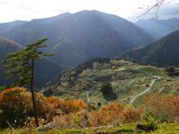
Visitors to the village pay a small fee for up-keep before ascending a hillside trail to an observation area - a cleared space on the hill. The views of the tea fields below, surrounded by montains, are said to resemble those of Peru's Machu Picchu, and it has been called "Machu in Picchu in Gifu", or "Kachu-Picchu", which I like a bit more, after the area, Kasuga. Properly the site is called the 'Kamigare Tea Plantation'.
Kamigare is the name of the terraced plateau and village - and the former castele or manor hall which was the centre of the Ojima Manor. Kamigarejō later became the kyokan (residence) paired with Ojimajō on the mountain to the northest. Ojimajō is therefore sometimes also called Kamigarejō, but the latter's origins are older, Ojimajō being a Sengoku period yamajiro (mounaintop castle).
Kamigare is the village on the rise, the tea fields here having been cultivated for a long time (sources vary on for how long, and mulberry was also an important resource here until relatively recently), deep in the mountains at an elevation above 300m. The commune of Rokugō, which Kamigare is in, further includes another settlement, Shimogare - I think, in the valley beside the Kasu River. A few hamlets are scattered along the riverside and hillside. Rokugō is part of the former Kasuga Township which was merged with Ibigawa Township (see the 'Great Heisei Municipal Mergers'). Some sources refer to Kamigare as Kasuga, but Kasuga is the quite expansive mostly mountainous area containing Kamigare village.
The tea grown in Kamigare is organic, not treated with pesticides or fertilisers. The patterns formed by uneven rows are lovely, but the tea bushes are grown close together and are sheered to the same height in order to prevent weed growth and ensure adequate sunlight. Tea plantations like that of the Chaboboen farm have been cultivated in Kasuga, it is said, for seven centuries.
I'm not sure Kamigare is quite Machu Picchu, but the views of the tea fields shown here are indeed beautiful. The tea bushes themselves form interesting patterns. It's hard to believe that centuries ago this serene and bucolic setting was the stage for a complex of fortifications centred around Kamigare. In addition to Kamigarejō and Ojimajō (then known as Kidojō) on the mountain to the east, there were at least three forts on the ridges on the north side of the Kasugawa; Shimogarejō was located on a hill to the south (it is now also a tea plantation).
Note: Kamigare is now usually written as 上ヶ流, but previously it was written 上狩宇, and this is the proper name for the castle, often misread as 'Kamiǵaryū (the kanji 上狩宇 looks like "Kamigariu")'.Kitagata Castle (Motosu) / 本巣北方城
The homes in this area actually look quite new, so this is a sign that there may have been actual ruins of fortifications up until recently. Sure enough, some old pictures I found online show a monument surrounded by a bamboo grove. One webpage, curiously linked to the official site of Sukomo Municipality in Kōchi Prefecture, describes the trepid explorers to this site finding 50cm tall earthen mounds and a 1m wide ditch in the bamboo grove; I wonder if these were castle ruins... The picture attached is black and white, and looks decades old; here: https://www.city.sukumo.kochi.jp/sisi/026301.html
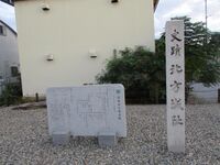
Note: This is Kitagatajō in Motosu County, not to be confused with Kitagatajō in Ibi County, both in Mino Province / Gifu Pref..Kitagata Jin'ya / 北方陣屋・本巣北方城
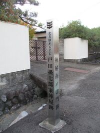
Whilst no ruins of Kitagata-jin'ya remain on-site, four gates, out of a total of thirteen which originally stood at the jin'ya, have been relocated to the surrounding area, and I was able to visit three of these. Albeit, by the time I reached one of those, it was already dark.
Three of the gates are located on private residences, but they can be seen from the roadside. Of these I visited two: one to the south of the jin'ya site known as the Ishimachi-kidomon ('stone town gate'), and one to the north of the jin'ya site, actually in the Nishikaiden Township of neighbouring Gifu Municipality, known as the Honmachi-kidomon ('downtown gate'). A kidomon refers to a more humble type of gate chiefly used for samurai residences; they are not designed to withstand a siege.
The third and final relocated gate from the jin'ya I visited is at the Nishi-Honganji Gifu-betsuin temple in downtown Gifu, serving now as the temple's rear gate. My apologies; it was already dark by the time I located the relocated gate. This gate, which seemed the most impressive of the jin'ya's gates to me, was known as the Shinmachi-kidomon ('new town gate'). The fourth surviving gate, which I didn't visit, is located in Itonuki Township, Motosu Municipality; I actually wasted valuable time searching for it before realising I had no idea where I was going. The gate in Itonuki was known as the Masuyamachi-kidomon.Kodera Castle (Mino) / 美濃小寺城
Nagamatsu Castle (Mino) / 美濃長松城
Nakano Castle (Motosu) / 本巣中ノ城
Nakanomiyama Castle / 中深山城

Nomura Jin'ya (Mino) / 美濃野村陣屋
Ochiai Fort / 落合砦
Ruins of Ochiai-toride include terraces, baileys, trenches and berms. The park's main attraction for more casual visitors might well be a deep, stone-lined well said in local lore to be the place where the water was drawn for Akechi Mitsuhide's first bath after his birth. So, we must suppose Akechi Mitsuhide was born here.
That said, an important disclaimer here would be that there are multiple locations claimed as the birthplace of Akechi Mitsuhide throughout Mino. Wikipedia says he was born at 'Tara Castle' and thus Ochiai-toride is also called Tara-toride, but the article specifies that 'Tara Castle' is in Kani, so it's probably talking about Akechi-Osayamjō. It's disputed as to whether that site was even a fort (though I think it was, having been there). So, it's stated somewhere that Akechi Mitsuhide was born at 'Tara Castle' but does anybody know for sure where that was? It's a mystery where Akechi Mitsuhide was born. And so we should remain sceptical and require evidence. Historians dispute the theory of Akechi Mitsuhide descending from the Toki branch of the Akechi Clan, so it's all up in the air.
The layout of the fort is of two twin baileys on dual peaks with a flattened 'saddle'-like area between them. Akechi Mitsuhide's well is in the saddle. The northern bailey is more simplistic in structure, and is referred to as the kita-demaru, or 'north outer bailey'. Today it is a look-out area with commanding views of Akechi. The main bailey is surrounded by many terraces and there are some traces of mounds and a tatebori (climbing trench).
Ochiai-toride's simplistic structure compared to that of Akechijō's may lend credence to the theory that Ochiai-toride was the old Akechijō (add 'Akechikojō' to the list of names?), and that the Akechi Clan's original residence was here (or, more accurately, in the valley below the castle-mount). Otherwise or additionally, Ochiai-toride was later a satellite fort of Akechijō.
Because the site has been developed as a park, some of its original structure may have been effaced. I was curious as to the extent of the flattened area on the inside of the peaks, and whether this could've contained a manor hall, as per the name 'Senjōjiki'. The path down from the park to the village may have also been a fortified ridge at some point, but now it's hard to tell. Curiously there is a tree here growing very deliberately and obstructively, horizontally across the path.Ojima Castle (Mino) / 美濃小島城
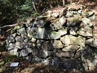
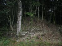
Features of Ojimajō include horikiri (trenches), tatebori (climbing trenches), ishigaki (stone-piled ramparts), dorui (earthen ramparts) and terraced baileys. Because of the extensive terracing throughout the castle's footprint the only none-terraced bailey is the topmost. This is called the first bailey, but probably didn't function as the main bailey, and was more like a look-out space. To the rear of here is the site's only horikiri, which bisects the ridge, and is wide, deep and sloping, quickly becoming tatebori like the rest of the hori (moats) found at the castle. Further, the castle's only dobashi (earthen bridge) spans this large moat, and is one of the longest dobashi I've seen at a yamajiro.
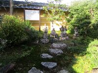
The lower baileys of Ojimajō now host a shrine to Kwannon. When I visited, the autumn colours at this altitude were effulgent. Naturally, the terraces narrow as they climb, though the second or penultimate bailey is quite spacious and appears to contain a stone-lined well. The upper castle is now mostly used as a cedar plantation. These terraces are bounded in the west by a huge tatebori stretching all the way down the mountainside.
I found three decent sized blobs of ishigaki throughout the ruins. The most impressive segment is squeezed between two short tatebori on the side of the upper bailey cluster. It looks like it must collapse totally one day, and already has in parts, but it is beautiful. It's hard to find so I'm glad I didn't miss it.Saitou Toshiyasu Yakata / 斎藤利安館
In the temple hall's genkan (entrance parlour) there is an old monochrome aerial photograph showing the temple from above. Maybe it dates to the 1930s or 40s. The temple is surrounded by a dense thicket in a square formation. Surely, thinks I, inside those thickets were moats and ramparts which surrounded the old manor hall. But, alas, they're long gone now, as are the surrounding fields and huge prison complex shown in the photo, all now swallowed up by residential sprawl.
I should add that the temple hall also contains an old shachihoko roof finial said to have been originally erected at Kiyosu Castle (but I don't have a picture, I think because it came out blurry).Sarubami Castle / 猿啄城
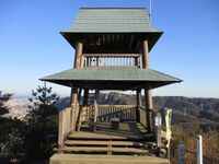
The views from the mogi miyagura are excellent. The tallest snow-capped mountains visible are in Nagano, ranging from Mount Kenǵamine and the Kiso Mountains to the Southern "Japanese Alps". Mount Hakusan to the west is also apparent. Nearer by, the township of Sakahogi is spread below. A school in the middle of a hilly forest can be seen and it looked scary and outré to me surrounded by trees, but it's just the town's middle school. To the southwest neighbouring Kakamiǵahara Municipality can be seen. In the distance the skyline of downtown Nagoya is visible. Indeed, the view is commanding.
After climbing up to the tower I stayed for a while enjoying the warm sun, the view, and a large amanatsu I had brought. As I ate I amassed a pile of peelings from the astringent fruit and wondered if I was the monkey of Sarubamijō, picking at my citrus. Unfortunately in my rapture I forgot to check the rear of the main bailey for any trenches. Not many sources mention it, but according to Jōkaku Hōrōki there is a trench system spanned by a dobashi (earthen bridge). I did remember half way back down the mountain, and took a side path wondering if it would swing around and up, but it just took me further away, and by then time was getting on. Ah, well.Suishouzan Encampment / 水晶山陣
Taishou Encampment (Ena) / 大将陣
There is a small shrine and a war memorial, as well as some signboards about the jinsho site. One signboard was for a marker commemorating Iwamura Castle and the siege to which it succumbed.
Note: 'Taishō-jin' is a fairly generic name, and there are other famous encampment sites with this name. This site is in the historical Ena County. Although perhaps more properly called the Oda-Nobutada-honjin, Oda Nobutada had many such encampments in his career.Tama Castle (Mino) / 美濃玉城
The rear trench complex is this site's highlight - for me. The array of tatebori, one after the other, on the fort's western slope, are also impressive. Piles of stones arond here suggest either some masonry was used, or a large amount of stones were kept around to be used as projectiles. Some features I found did not appear on the map I was using, including a well site.
To reach Tamajō I rented a bicycle from the souvenir shop across from Sekiǵahara Station. I got an electric one so as to cycle on the forest road which leads to the trail to Tamajō. Afterward I went to the Sekiǵahara Limestone Cave, which was full of bats - and even a type of trout (masu) that lives in subterrene streams there.Yamaguchi Castle (Mino) / 美濃山口城
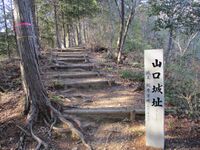
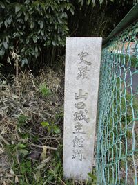
Yamaguchijō is also distinguished from the other forts in the group by its obikuruwa (ring bailey) surrounding the main bailey. The obikuruwa has some indications of having different levels or slight terracing. There is a gate ruin to the side of the modern entrance to the main bailey.
I had hiked in a big circuit starting from Motosu Station and climbing to Kakeborajō (which for me is the most impressive fortress in the Monjuyama group). I then walked the ridge to Ikoyamajō, continued on to Hōrinjijō, and descended thence before sweeping back up to reach Yamaguchijō. For the first time that day I encountered other people, as an elderly couple came up along the steep stairway along the ridge between the sites of Yamaguchijō and Nakanojō. I said to the old man "Steep, isn't it?" and he said "Not at all!". Oh!
This site is Yamaguchijō in Mino Province, not to be confused with Yamaguchijō in Suo Province (Yamaguchi Prefecture).Yamaguchi Yakata (Mino) / 美濃山口館
The yakata site is located right beside the Tarumi Railway and Oribe Station. There is a marker for the yakata at the edge of the property, and a signboard about it on the station platform. On the opposite side of the tracks from Yamaguchi-yakata is the Oribe Roadside Station ('michi-no-eki'). I'd actually visited this place before because of the large castle folly it has. Rather than a tower, there is an Edo period-style yaguramon (gatehouse). Sometimes it's possible to enter, but when I first visited there was some kind of alternative medicine workshop / scam going on inside, and this time I didn't have time to check. The yaguramon, called "sanmon", likely dates to 2001.
The rest-stop is also called 'Oribe-no-sato', so the yaguramon is like a ceremonial entrance for this "village". Additionally there is an exhibition hall, and the displays introduce Furuta Shigenari who was born at the yakata, so the yaguramon and village appear to be purposeful in their relation to the yakata. Maybe they wanted to build the yaguramon on the yakata site but the landowner wouldn't sell, or cooler heads deterred them from doing anything so silly. Of course, an Edo period yaguramon would not have been built at a Sengoku period yakata! The yakata does not seem to have featured any ishigaki (stone walls) either. For me, there is really no relation between the yakata and the folly, but for more casual history fans maybe the connection is more intuitive. Basically, I think we should treat the yaguramon as an ahistorical faux-reconstruction of the yakata. Anyway, it's a fun bonus for Sengoku history enthusiasts (as for castle-bloggers, Kyūtarō (no Sengoku shiro meguri) rejoices in the folly, whilst Jōkaku Hōrōki coldly ignores it).Recent News
Sep 28, 2025
Yagyu Castles, Chihaya Akasaka Forts, and Kaibara Jin'ya
Sep 20, 2025
ART added 33 new castles across central Japan
Jul 29, 2025
31 new profiles from ART for Gifu Prefecture
Jul 19, 2025
Battle of Shizugatake Feature + 17 new castles
Jul 8, 2025
34 new profiles from ART for Shizuoka and Yamanashi
Jun 7, 2025
Comment System Upgrade
May 24, 2025
Four new castles around Sasayama Hyogo
May 16, 2025
10 Kyoto Castles Update May 2025
Mar 23, 2025
Hagi Castle & Hagi Castle Town Project
Jan 23, 2025
Bitchu Matsuyama Castle and Ohmatsuyama Castle Updates
Jan 3, 2025
2024 Jcastle cleanup and Happy New Year 2025
Dec 10, 2024
Sayonara Google Maps
Dec 2, 2024
Tsuyama Castle Update and 500th Castle Visited
Nov 11, 2024
Jcastle Rebuild 2024
Oct 3, 2024
11 New Castles around Kyoto
Sep 30, 2024
ART's New Profiles for Aichi Prefecture
Sep 22, 2024
5 new Okinawa Castle Profiles
Jul 27, 2024
Mikazuki Jinya, Kohyama Castle, and updated Hikone Castle
Jul 22, 2024
28 new profiles from ART
Jul 7, 2024
5 Castles from Ayabe City in Kyoto