ART Update 2022 Part 5

From Jcastle.info

Part 5 of ART's updates from the first half of 2022. See the castles and map below for details. If you haven't seen his Facebook Japanese Castle Group yet I highly encourage you to do so. There are contributions from a variety of members, discussio

ART Update 2022 Part 5

2022/09/13


Part 5 of ART's updates from the first half of 2022. See the castles and map below for details. If you haven't seen his Facebook Japanese Castle Group yet I highly encourage you to do so. There are contributions from a variety of members, discussion and news about castle developments and discoveries.


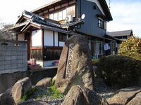
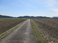
Asahara Yakata / 浅原館
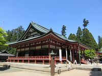
AsaharaYakata (1).JPG

Nought but a stone memorial tablet remains of this fortified manor hall, Asahara-yakata.
 
Enryakuji / 延暦寺

Enryakuji (2).JPG

The main hall of Enyrakuji is the Konponchūdō, located in the East Wing of the temple. It is currently under renovation and so I did not take any photographs of it. The Konponchūdō is the centre of the temple complex and was its main base in most of its major conflicts, being torched to the ground many times. The temple complex was protected by a network of forts. I visited seven of these fort sites located in the western and eastern wings of the temple complex. These forts are named for what part of the temple they were in. I list them below. I will detail each site in separate profiles. This article is an overview outlining the history of the site, and pictures show the central area of the temple complex and various miscellaneous structures which are not related to any of the fortified areas.

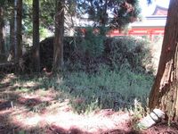
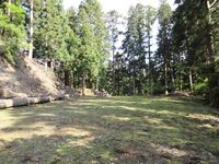
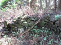
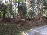
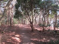
Toride (fort) sites I visited:

延暦寺阿弥陀堂砦 Enryakuji-Amidadō-toride (Enryakuji Amidadou Fort)

延暦寺文殊楼砦 Enryakuji-Monjurō-toride (Enryakuji Monjurou Fort)

延暦寺北谷砦 Enryakuji-Kitatani-toride (Enryakuji Kitatani Fort)

延暦寺浄土院砦 Enryakuji-Jōdoin-toride (Enryakuji Joudoin Fort)

延暦寺釈迦堂砦 Enryakuji-Shakadō-toride (Enryakuji Shakadou Fort)

延暦寺西谷砦 Enryakuji-Nishitani-toride (Enryakuji Nishitani Fort)

延暦寺東谷砦 Enryakuji-Higashitani-toride (Enryakuji Higashitani Fort)

There are many other toride sites besides, including in the areas of the historical Hiyoshi-shinguuji, Ichijouji, and the Yokawa wing of Enryakuji. I should like to visit all of these eventually.
 
Enryakuji Amidadou Fort / 延暦寺阿弥陀堂砦

EnryakujiAmidadouToride (19).JPG

The Amidadō-toride was the first fort site I came to in the Enryakuji temple-fortress complex. This site is so called because it is centred around the temple’s hall to Amida. The ruins here chiefly consist of dorui (earthen ramparts) and terraced areas which served as baileys. The site of the temple halls, including the reconstructed East Pagoda, were presumably the main bailey. The largest dorui segment can be found to the north of the Amidadō. There is also what looks like a tatebori (climbing moat) beneath here, but it could be something else since I found no other such trenches that day. To the south is a ridge with flattened spaces which overlooks the East Pagoda, which I also inspected. If military considerations were absolute then it would not be the case that the fort should be centred on the halls as opposed to on the elevated portion of the ridge, but the original temple structures were fortified where they stood. In this way the Enryakuji forts are very different from other mountaintop fortifications – those of the samurai. Nonetheless the use of tall and thick earthen ramparts is typical of medieval earthwork fortifications, and it was gratifying to find some at Amidadō-toride.

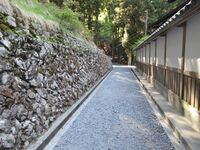
I felt a bit of an outsider snooping around for fort ruins whilst everybody else was busy praying or admiring the temple architecture. This area of the temple was mostly rebuilt in 1937. The use of the term ‘tower’ or ‘pagoda’ refers to two of the temple’s three main areas. This can lead to confusion. The East Pagoda is the temple’s eastern wing or portion, and the West Pagoda is its western zone. The wings were named for the pagodas which originally stood in them. The ‘Japan Experience’ confidently tells us that both pagodas, referring to the buildings themselves, are long gone, but in fact the East Pagoda itself was reconstructed in 1937 (largely out of concrete). The website says that erroneously despite showing the East Pagoda in their pictures. There’s probably confusion as to what the word ‘pagoda’ means here. Whilst most associate East Asian pagodas with tall and slender towers of usually an odd number of tiers, such as at Japan’s Hōryūji or China’s Dàyàntǎ (Giant Wild Goose Pagoda), there are many forms of pagoda. Different words associated with different forms are actually just words for the same structure, defined by function, in various languages. Dagoba (not uncoincidentally the name of a certain Jedi’s famous hermitage I'm sure) is Sinhalese, Stūpa is Sanskrit, and Chorten is Tibetan; they’re all fundamentally the same in their purpose. The Kanji / Hànzì is 塔, which is ‘tō’ in Japanese and ‘tǎ’ in Mandarin. Anything ending in 塔 in Japanese then is a type of pagoda (I have acquainted myself with most of the forms). The pagoda at Enryakuji is a tahōtō (多宝塔), a type of stūpa developed in Japan, and related to the also native hōtō (宝塔). Hōtō means ‘treasure tower’ and a tahōtō is a hōtō with an additional tier (the former is more common than the latter at full size). Other pagodas are described in terms of the number of their tiers: sanjū(no)tō, gojū(no)tō and so on. The word covering all forms in Japanese is 'buttō 仏塔', meaning 'buddha tower'. At Enryakuji the East Pagoda, albeit as a modern reconstruction, stands, but the West Pagoda does not.

The Amidadō is connected to the Tōtō (East Pagoda) and other structures via a kairō (cloister, or roofed walkway), and one passes into the complex through an ornate gateway. There is also a shōrō (belfry) at the fort site. The terrain slopes from here and one descends to the site of Enryakuji’s main hall, the Konponchūdō. This is the end of the fort site. There is another fort site on the opposite side of the Konponchūdō, the Monjurō-toride (Enryakuji Monjurou Fort).
 
Enryakuji Higashitani Fort / 延暦寺東谷砦

EnryakujiHigashitaniToride1.JPG

The Higashitani-toride (‘East Valley Fort’) refers to the fortified area of the temple-fortress of Enryakuji in the east. I tentatively identified a karabori (dry moat), but the area appears to be mostly made of large terraces lining the mountainside. There are few buildings in this area of the temple. There used to be thousands of halls at Enryakuji, and these were mostly on the lower slopes of the mountain; only the core of the complex is retained today.
 
Enryakuji Joudoin Fort / 延暦寺浄土院砦

EnryakujiJoudoinToride (4).JPG

I didn’t find any ruins of fortifications at Jōdoin-toride, and I wasn’t sure where to look for them. The site is that of the Dengyō Taishi Gobyō, a mausoleum for Saichō, the founder of Enryakuji. Apparently a team of monks are dedicated to attending the mausoleum and they must never leave the mountain. I wonder if they can visit a hospital if they get sick? The site is in the middle of a ridge or slope of the mountain. From below the ridge looks flattened in tiers. It’s hard to visualise the fort as solely being the mausoleum, and so maybe the whole ridge was fortified. I didn’t poke around too much at this one, since I didn’t want to be seen as trespassing in the temple’s most sacred area.
 
Enryakuji Kitatani Fort / 延暦寺北谷砦

EnryakujiKitataniToride1.JPG

The Kitatani-toride (‘North Valley Fort’) is one of many terraced ridges surrounding the temple-fortress of Enryakuji. Searching for its exact location I came across many terraced areas and the impression I got was of a fortified mountain, of which the forts I was searching for were merely nodes or clusters of dense fortifications within a contiguous sprawling expansion of baileys and embankments, which would’ve had walls, stockades and temple halls which could double as barracks. I found many long neglected ishigaki (stone walls) in these shady areas too. Some were in a state near to collapse, and their complete crumbling had been forestalled only by a fortuitously situated tree bowl or such. The main area of Kitatani-toride can be accessed by descending via a trail from the temple’s carpark. Here the terracing is tall and the flattened spaces are wide. I even thought I might’ve found the remains of a karabori (dry trench). These features make it the fort’s centre but from various dubious shortcuts I took I can attest that multiple ridges are terraced, and this makes me think that the fort covered a large area at the temple’s northern lower terraces. These terraced baileys would’ve contained barracks for ‘warrior monks’ and lodgings for worshippers. It is thought that the entire complex could’ve held up to 20,000 people, including thousands of monks, soldiers and their dependents in times of siege.
 
Enryakuji Monjurou Fort / 延暦寺文殊楼砦

EnryakujiMonjurouToride (3).JPG

This fort ruin is the most easy to identify, I feel, as a toride site because dorui (earthen ramparts) ensconce much of the bailey, now the site of the Monjurō (thus the fort’s name), a tiered gatehouse. The Monjurō is considered Enryakuji’s main entrance. I found a marker here which designated historical ruins, but there was no information presented on-site.
 
Enryakuji Nishitani Fort / 延暦寺西谷砦

EnryakujiNishitaniToride (3).JPG

The Nishitani-toride (‘West Valley Fort’) refers to the fortified area of the temple-fortress of Enryakuji in the west. There is a peak along the ridge which separates Kyōto and Sakamoto with a monument on it. The monument appears to be a sōrin, or steeple which crowns a pagoda. Around this area there appears to be the remains of the fort, including terracing, kirigishi (shaved mountainside), dorui (earthen ramparts) ensconcing bailey spaces, and maybe even a koguchi (gate area). Viewed from the forest road below an area where I tentatively identified dorui looks like the earth was worked into terraces with ramparts atop. This must be part of the Nishitani-toride, I thought, but I don’t know how extensive it used to be.
 
Enryakuji Shakadou Fort / 延暦寺釈迦堂砦

EnryakujiShakadouToride (1).JPG

Shakadō-toride is the site of the Shakadō, Enryakuji’s Buddha Hall, which is the oldest building at the temple, having been relocated from off-site after the rest of the temple was destroyed by Oda Nobunaga (barring Ruridō, a small, hidden hall, but Shakadō is still thought to be older). Other temple structures were rebuilt in the Edo period or later, and so though much of the core of the temple has been reconstructed, in the case of the Shakadō an older ‘borrowed’ structure was used instead. Around the hall there is the mountain and the hall seems to sit in a hollow in the earth. The western ridge, which is the boundary by the way between Kyōto and Sakamoto, appears like a ridge which was used as dorui (earthen ramparts). This area can be considered the heart of the temple’s western wing. Above the Shakadō is the Ninaidō, twin halls connected by an overhead walkway, associated in legend with Saitō Benkei, the Heian period warrior monk. The ‘Saitō’ in his name is not the regular family name Saitō (斎藤), but refers to this western wing of the temple (西塔). Apparently Benkei could lift the Ninaidō over his shoulders like a pair of weights. Another fanciful yarn involving the famous sōhei sees him pinching a large bell from rival temple Miidera, only to kick it back there again from Enryakuji when the bell wouldn't sound properly.
 
Gamou Funaki Castle /

[[|200px|link=Gamou Funaki Castle]]

 
Gamou Ikeda Yakata /

[[|200px|link=Gamou Ikeda Yakata]]

 
Gamou Kitanoshou Castle /

[[|200px|link=Gamou Kitanoshou Castle]]

 
Gamou Kongouji Castle /

[[|200px|link=Gamou Kongouji Castle]]

 
Gamou Kounoshou Castle /

[[|200px|link=Gamou Kounoshou Castle]]

 
Iba Castle / 伊庭城

Ibajou (1).JPG

Ibajō is like a small version of Ōmi-Hachimanjō, except flatland, due to its waterways lined with ishigaki (stone walls). The waterways are more like irrigation channels than canals, though some permit small boats. These bucolic waterways were used for daily life, transport, farming fish, and also as moats by the castle. When I was wondering around I came upon a gaggle of children. They stopped to gaze at me. Unfortunately this meant one of them dropped a plastic bottle into the waterway, and so they mobilised to retrieve it, fetching buckets and poles with nets on. It was nice to see the children (noisily) taking care of their local heritage.
 
Iba Palace / 伊庭御殿

IbaGoten (1).JPG

The ruins of Iba Palace include ishigaki (stone walls). The site was extensively excavated in the mid' eighties. It is maintained as a small park but it was closed when I visited. Iba-goten is registered as a National Historic Site. The nearby temple is Daitokuji (大徳寺), which is notable in its name, perhaps suggesting some link to the Tokugawa shoguns and Iba-goten.
 
Ibako Castle / 伊庭古城

Ibakojou (2).JPG

No ruins remain of Ibakojō and the site is now rice paddies.
 
Ibayama Castle / 伊庭山城

Ibayamajou (2).JPG

Ibayamajō is a minor yamajiro (mountaintop castle) located on the ridge between Sasōjō and Kannonjijō. Though seemingly a small fort site, the shukuruwa (main bailey) is surrounded by dorui (earthen ramparts). The shukuruwa is about 100m by 40m. There is evidence of terracing of the mountain slope beneath the shukuruwa to the east. The koguchi (main gate) is situated above this obikuruwa (belt bailey). The castle's footprint is actually thought to be quite large but its outer fortifications are hard to delineate - or they were for me, at least. I didn't fail to notice the very obvious remains of a kofun (ancient burial mound) along the trail, however. The ridge which continues on after the shukuruwa looks like it has been flattened in places and I identified some tatebori (climbing moats), but I probably only covered a small fraction of the castle site. The castle ruins extend south along the ridge and to the north toward Inoko.
 
Inoko Yakata / 猪子館

InokoYakata (1).JPG

Inoko-yakata was one of several fortified manor hall sites clustering around a long mountain which contained several mountain redoubt fortifications. Mount Inoko, which is now the site of a temple, I wondered about too. Was there a redoubt here used by the Inoko-yakata? Since there was already a Sanoyamajō (Sasōjō) corresponding to the Sano-yakata sites, an Ibayamajō mirroring Ibajō, and Kitasudayamajō parallel with Kitasuda-yakata, maybe the mountain was too full of fortifications already though! The peak of Mount Inoko is located between Sasōjō and Ibayamajō. There are no ruins at the Inoko-yakata and the site is now former farmland built over recently with suburban homes. Some pictures online show a raised field with what looks like it could be dorui (earthen ramparts), but I think this has already been developed over. 'Inoko (猪子)' means 'wild boar piglett'. That's a weird name. I wondered if it could also mean 'badger (獾・穴熊)'.
 
Jionji Yakata / 慈恩寺館

JionjiYakata (1).JPG

No definitive ruins remain of Jionji-yakata, a fortified residence, and the site is now fields bordering a river and that of the temple Jōgon'in (浄厳院). On two sides of the temple there are embankments, however: there are stone walls on the northern stretch, and the walls are higher on the outside of the temple than within, and the southern stretch separates the temple and a bamboo grove from neighbouring fields. The temple Jōgon'in has old architecture and is worth a visit. See also Gamou Kongouji Castle.
 
Kaminagahara Castle / 上永原城

Kaminagaharajou (4).JPG

Although no remains can be seen of Kaminagaharajō today, excavations in 2002 revealed that the castle was protected by a 100m long dorui (earthen embankment) up to 4m tall, and a moat which was 9m wide. These ruins, thought to have surrounded the castle's second bailey, have now been developed over with housing. Kaminagaharajō is now the site of a school; there is a marker for the site somewhere on the school grounds.
 
Kanzaki Amidadou Castle /

[[|200px|link=Kanzaki Amidadou Castle]]

 
Kanzaki Ishibayama Castle /

[[|200px|link=Kanzaki Ishibayama Castle]]

 
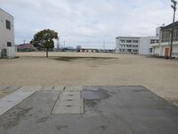
Kita Tsuda Castle / 北津田城

GamouKitasudajou (1).JPG

Kitatsudajō is a hilltop yamajiro (mountaintop castle) - you read that right - ruin located above the shrines of Ôshima-jinja and Okitsushima-jinja. Although the ruins are in poor condition and the site is now forested and a little overgrown, several baileys can be discerned, and the main bailey measures 40m east-west and 20m north-south. Earthworks ruins such as koguchi (gate complex) and kuruwa (baileys), including an obikuruwa (belt bailey), remain. See also Minami Tsuda Castle and Tsuda Castle (Omi) for more information.
 
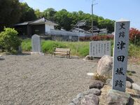
Minami Tsuda Castle / 南津田城

GamouMinamitsudajou (3).JPG

I visited Hachiōji-jinja and Shinnenji temple, finding markers for 'Tsuda Castle' and signboards detailing the history of the Tsuda Clan (particularly its folkloric association with Oda Nobunaga). There is a memorial garden to the castle and Tsuda Clan in the village of Minamitsuda opposite Shinnenji. Although I was following the Jōkaku Tanbō blog, I did not climb on the mountainside in the footsteps of my illustrious predecessor in an attempt to check for ruins there because I could not find a way up from Hachiōji-jinja. The hillside has been worked but it is unknown if these ruins are that of Minami-Tsudajō. For more information see Tsuda Castle (Omi) and Kita Tsuda Castle.
Loading map...


1
Loading comments...