44 new castle profiles from ART

From Jcastle.info

ART, the tireless castle explorer, has added 43 new castle profiles from Nagano Prefecture and one in Yamanashi Prefecture. There are a lot of great new Mountaintop Castles and some Fortified Manors. The Iiyama Castle profile is especially interesting and I'm glad to

44 new castle profiles from ART

2020/12/11


ART, the tireless castle explorer, has added 43 new castle profiles from Nagano Prefecture and one in Yamanashi Prefecture. There are a lot of great new Mountaintop Castles and some Fortified Manors. The Iiyama Castle profile is especially interesting and I'm glad to get this up there. I've been in the area a few times for hiking or visiitng friends but never got an opportunity to visit this great site. I need to prioritize it for next time !


Chausuyama Castle (Chikuma) / 筑摩茶臼山城

ChikumaChausuyamajou01.JPG

Chausu refers to a hand mill used for grinding tea, and mountains called for this tool are not uncommon in Japan (and, speaking of which, there's another one in the same historical county, listed on this site as Chausuyama Castle (Shinano) to distinguish them). The Chausuyamajō here is located in the foothills which surround Akashina, and is much further down from the tall mountains which soar beyond. Nevertheless, there was no trail to this site and the fallen leaves made climbing it difficult. There are a couple of baileys. They are overgrown with young bamboo. Not the best site but coming here allowed me to get some more views of the Koyajō castle mount.
 
Fukakusa Yakata / 深草館

FukakusaYakata (1).JPG

Fukakusa-yakata ("Deep Grass Hall") is a small hirajiro (flatland castle) site south of Yatojō. It has two baileys, with dorui (earthen ramparts) dividing the two. In the middle of the dorui is a koguchi ("tiger's maw") gate ruin. The northern enclosure is surrounded by dorui on all sides. The southern enclosure is partially surrounded by dorui and is otherwise bordered by a creek to the southeast. The site is surrounded by karabori (dry moats), and a deep creek.
 
Fukushima Castle (Kiso) / 木曽福島城

KisoFukushimajou3.JPG

Kiso-Fukushimajō was the third yamajiro (mountain castle) site I visited in Kiso, after Kiso-Komaruyamajō and Uenodanjō, and it is the best preserved of the three, being located high up on a mountain overlooking the others. The castle ruins consist of three kuruwa (baileys) arranged in a row, a layout known as renkaku-shiki. Each bailey has steep earthen embankments forming the ramparts and is separated by dry moats (horikiri (trenches) trailing off into tatebori (climbing moats)). Around the ichinokuruwa (main bailey) is an obikuruwa (belt bailey), and another koshikuruwa (hip bailey) partially surrounds the ninokuruwa (second bailey). The sannokuruwa (third bailey) is small without sub-baileys around it. Many sub-baileys extend beyond the ichinokuruwa, protecting the castle's mountainside flank. These pocket baileys terrace the mountain slope as it descends. The trail here leads to the site of a waterfall. Both trails lead back to town but I came and went by the more direct one, taking a shortcut from the daikansho (Yamamura-daikan'yashiki). The trails are well maintained for the most part, though the aforementioned shortcut to the daikansho has some narrow parts with rocks and trees across. The castle ruin's such as moats and baileys are signposted (in Japnese only). The castle itself is signposted from the hiking trail, so one should have no problem finding and exploring this site, an example of a basic Sengoku Period yamajiro.
 
Fuse Castle (Sarashina) / 更級布施城

SarashinFusejou01.JPG

I came here because I had a norikae at Shinonoi Station. My layover was twenty-seven minutes but it only took fifteen minutes to come here, read the sign board explaining about the site, and go back - after taking a few pictures of the area. As you can see, it's just parking. Why did I bother taking pictures? I was amused as I did so. Even though it bills itself as a castle site, Fusejō was definitely on the yakata (fortified manor house) side of things, though it did have an extensive mizubori (water moat). The neighbourhood today is called Uchibori, meaning "inside of the moat".
 
Houshouji Fort / 宝生寺砦
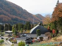
HoushoujiToride01.jpg

It was already dusk and getting dark when I stumbled across Hōshōji-toride. The ruin of this fort is located on a small hill. It is easy enough to reach, being right next to the road, but when I visited the site it was overgrown with prickly grasses which made exploration difficult. Despite this it was fun to run around as quick as possible trying to get a sense of the castle's layout before it was enveloped in darkness, and it's always a pleasant surprise to be able to visit one extra castle site! As the name implies, Hōshōji-toride is also the site of a temple, though that is now also just a ruin. Ishigaki (stone walls) at the foot of the hill were part of the temple rather than the fort, but they look old and whet one's appetite for castling. The ruins of the fort consist of a series of baileys and mounds, including sub-baileys terracing the hillside. One large koshikuruwa (sub-bailey) is evident below what I took to be the main bailey, and it seems the former temple site consituted another large bailey lower down.
 
Iiyama Castle / 飯山城

Iiyamajou01.JPG

iyamajō is a major Edo period castle site, the former centre of the Iiyama Domain. The castle ruins consist of both dorui (earthen ramparts) and ishigaki (stone-piled ramparts). The castle's footprint has been mostly preserved as a park, and the dorui is in great condition, being free of weeds and also restored to its original state in places, which regrettably we do not often get to see. The ishigaki is also nice-looking and fairly tall.

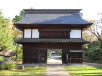
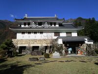
The main entrance to the main bailey is a masugata ("box-shape") gate complex formed from ishigaki. This gate complex only had a large rear gate, a yaguramon (turret-gate), and no forward gate. It seems there are plans to reconstruct this yaguramon. Another yaguramon has already been reconstructed in one of the castle's outer baileys, though it seems that it contains building materials from an Edo period gate which was relocated away from either the castle (the castle possessed fifteen gates in all) or a high-ranking retainer's home, and served as a nagayamon (rowhouse gate) at a private citizen's home after the castle was decommissioned. So this gate is simply referred to as "rebuilt gate", though it is not a reconstruction of any one specific gate at the castle.

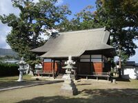
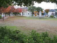
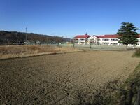
The honmaru (main bailey) is mostly surrounded by ishigaki and now possesses a shrine (elsewhere there is modern ishigaki but it looks okay). There are many other baileys, and integral baileys include the ninomaru (second bailey), sannomaru (third bailey) and nishinomaru (west bailey), the latter having restored dorui around it. Smaller baileys and outer baileys are also maintained. What was once an area for horses and stables is now a school field, but most of the castle can be accessed, having escaped modern development.

Municipal structures on site include an archery range and martial arts hall, which I suppose is fitting. The town of Iiyama is also nice and has a small mountain town feel to it. There are many temples dating to the Edo period at the foot of hills, and these can be visited if one takes a back road between Iiyama Station and the castle site, though the closest station to the castle is Kita-Iiyama Station. Everything can be seen on foot. The municpality also contains ski slopes and the first ski enthusiasts in Nagano were apparently from Iiyama, even practicing skiing at the castle!

Iiyamajō (飯山城) is one of what I've dubbed 'he Big Ii Three', along with Iidajō (飯田城) and Iijima-jin'ya (飯島陣屋), all historically valuable Edo period sites in Nagano Prefecture, all containing structures.
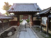
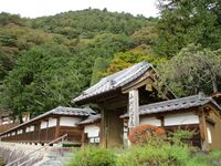
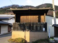
 
Kaesa Castle / 替佐城

Kaesajou01.JPG

Kaesajō is a fairly well maintained Sengoku Period yamajiro (mountaintop castle) which is very easy to hike to, as there is road access to the site, which is now a park. Although the slopes of baileys were a bit tangled with growth, important parts of the castle are cleared of trees, allowing us to appreciate them better. It seems that the baileys have recently been cleared of plant growth. Features include baileys, trenches and tatebori (climbing moats). An obikuruwa (ring bailey) rings the honmaru (main bailey), and there are two more integral baileys with sub-baileys surrounding them. At the base of the castle is a mizubori (water-filled moat), but it is hard to get near due to the densely growing flora surrounding it.
 
Karasaki Castle / 唐崎城
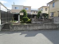
Karasakijou03.JPG

The castle's layout is "L" shaped roughly, with terraced minor baileys streaking off down two ridges. At the top is a large sub-bailey and two integral baileys, the latter partially surrounded by dorui (earthen ramparts), now heavily eroded. To the rear, where the mountain climbs, is a dry moat. The castle further features tatebori (climbing moats) here and there on the mountain slopes. These features proved difficult to photograph though. The town at the base of the castle is still called Amenomiya, Karasakijō being the castle of the Amemiya Clan, and the ruins can be accessed via a small shrine, Shōkonsha, at the foot of the mountain there.
 
Kazama Yakata / 風間館

KazamaYakata.JPG

The site of the Kazama-yakata is now a temple, Jōfukuji.
 
Kiso Daikansho / 木曽代官所

KisoDaikansho1.JPG

Kiso-daikansho is a daikansho (fortified offices / mini-castle) ruin in Fukushima village, Kiso Township, Kiso County. The Kiso-daikansho, more popularly known as the Yamamura-daikan'yashiki, was the administrative center of the Fukushima-juku, a post town in Kiso along the Nakasendō (Interior Mountain Highway). The Fukushima-seki, a checkpoint, was located here, and was one of the most important in the entire national road network of the Edo period.

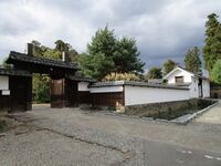
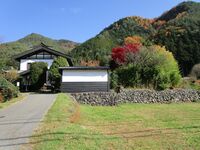
The Yamamura were representatives employed by the Owari-Tokugawa rather than daimyō, and thus they did not have a castle, but a daikansho. Nevertheless, they were an affluent family, due to the importance of their charge, and maintained townhouses in both Edo and Nagoya. And their yashiki (mansion) was large for a daikansho, and like a castle, with many layers of fortifications, including stone walls with parapets and gatehouses.

Unfortunately little of this complex remains today, though what does remain is valuable. Firstly there is a segment of ishigaki (stone ramparts) which once supported a gatehouse. Next are original residential structures used by the Yamamura which are now open to the public (paid entry). Not many daikansho structures remain throughout the country, so this is a special site.
 
Kiso Uenodan Castle /

[[|200px|link=Kiso Uenodan Castle]]

 
Kiso Yoshinaka Yakata / 木曽義仲館

KisoYoshinakaYakata01.1.JPG

No ruins remain of the yakata itself but there is a large stela proclaiming the site (木曽義仲公館址). Another monument (木曽宣公旧里碑) commemorates the 1813 visit by Yamamura Yoshiyuki (ninth patriarch of the Yamamura Clan). The Yamamura, governors of Kiso, were a family known for their literary talents. On the stela is enscribed a poem by Yoshiyuki which pays homage to Kiso Yoshinaka.
 
Kitsune Castle (Azumi) / 安曇狐城

AzumiKitsunejou01.JPG

There is a hill which juts out toward the Sai River. This was an ideal place for a fort, I've no doubt, though I could identify no ruins here, as the site has now been developed with houses, and ruins which remain are on private property and cannot be accessed. There were lots of persimmon trees here though, which I appreciated.
 
Komaruyama Castle (Kiso) / 木曽小丸山城

KisoKomaruyamajou1.JPG

I came to the site of Kiso-Komaruyamajō as part of a tour of sites in the area. Unfortunately there is not much to see here. The site of the honmaru (main bailey) is now an NHK radio mast, and the site of the ninomaru (second bailey) is now that of the town's high school. Both are off-limits to the general public. The honmaru is situated above the ninomaru on a rise. It seems the ninomaru was larger than the honmaru and wrapped partially around it, a layout called teikaku-shiki (ladder formation). The other side of the honmaru is steep natural elevation, which nowadays has the railroad at the bottom. When I came there were men working to cut back the grass around the radio mast. I thought there might be some climbing trenches at the sides of the honmaru but I couldn't get a close look. From here I proceeded on to Uenodanjō.
 
Komazawa Castle (Minochi) / 水内駒沢城

MinochiKomazawajou.JPG

I came here at the start of my impromptu walking tour of former castle sites in suburban Nagano. My plan had been to visit more yamajiro (mountaintop castles) along either the Iiyama or Shinonoi lines, but awkward schedules would've had me waiting around for hours. I decided I'd hit the Shinonoi line sites another time and just visit some minor sites in Nagano instead. It was a matter of quantity over quality though unfortunately as although I went to six locations I found very little to show for it. Likewise nothing remains of Komazawajō and the site is now that of a shrine, Kamikomazawa-Suwa-jinja, and a complex of maisonettes.
 
Koya Castle (Chikuma) / 筑摩こや城

ChikumaKoyajou02.2.JPG

The ruins of Koya Castle are located in a park named for the castle mount, but unfortunately the park seems to be no longer maintained, and is covered in tall grass which has swallowed up benches and gazeboes. The main bailey is full of young trees. The ridge used to access the park is still clear, and climbing trenches can be discerned along it which created choke-points used in the castle's defence. Koyajō is twinned with Chausuyama Castle (Chikuma) as they're on hills on opposite sides of the small Aida River. The lack of Kanji for こや城 is interesting. Probably no one could agree on whether it was supposed to be 古屋城 or 小屋城.
 
Matsuda Yakata / 松田館

MatsudaYakata03.JPG

Matsuda-yakata, also called Kannushi-yashiki, is a fortified manor house, rebuilt as a yashiki in the Edo period, not dissimilar to the Shimosaka-yakata. Unfortunately the main hall, which was around four centuries old, burnt down in 2017. Some restoration work has restored one of the damaged structures, but fire damage is still evident. Structures from the Edo Period, such as gates and out-buildings, nonetheless remain. The residential complex is surrounded by dorui (earthen ramparts). There is a large shrine adjacent, also partially surrounded by dorui. We may infer from the name Kannushi-yashiki that the shrine and yashiki have an interwoven history, since Kannushi refers to a Shintō priest in charge of a shrine.
 
Meiseireijin Fort / 明聖霊神砦

MeiseireijinToride01.JPG

When I arrived at the ruins of Meiseireijin-toride, I thought I had already come across Karasakijō, which is where I was heading. I couldn't mistake earthworks as anything other than castle-related. I checked my positioning and saw that I still had a little way to go before reaching Karasakijō, however. It was only later that I was able to identify this site as the ruins of a small fort called Meiseireijin-toride. The toride consists of a central bailey with a lower sub-bailey and a rear dorui (earthen rampart) segement, now lined with hokora (mini-shrines). Beyond the dorui is a sizable trench complex with a deep horikiri (trench) and tatebori (climbing moats) on both sides.
 
Motohori Yakata / 本堀館

MotohoriYakata.JPG

I stopped by the site of Motohori-yakata as part of my walking tour of former fortification sites in suburban Nagano. Although no ruins remain of this fortified manor house, a signpost can be found in a small garden in the middle of a suburban development area. It is next to a "grave for ancestors".
 
Motoyama Castle (Chikuma) / 筑摩本山城

ChikumaMotoyamajou01.JPG

This site was tricky to get to because there was no obious trail. I stuck to the ridge line as much as possible. The rocky mountain scenery was invigorating. The castle ruin consists of a series of spacious terraced baileys surrounding the uppermost bailey. Including the shukuruwa (main bailey), there are four tiers of sculpted earth in all. The koshikuruwa (sub-bailey) beneath the shukuruwa is surrounded by dorui (earthen embankments). The trench to the rear of the main bailey is very deep.
 
Motoyama Yakata / 本山館

MotoyamaYakata01.JPG

Now the site of the Motoyama-juku Honjin.
 
Nagao Castle (Azumi) / 安曇長尾城

AzumiNagaojou03.JPG

Although referred to as a castle, this site in Azumino Municipality, Nagano Prefecture, is very similar to the toride (fort) sites I investigated before summer along the Azusa River. Unfortunately little of the fortifications remain. The site is situated on a cliffline with a ravine cutting into it, so that the fort was snug on this promontory over the plain, protected on multiiple flanks. These pictures show the depression in the earth and cliff line, as well as things on the site now, which is mostly apple orchards in the outer baileys. The orchards were busy with families picking apples, and there were a lot of people around for such a rural locale. I found the grave site of Motai Chūzaemon further along the cliff from the fort site. It seems he was involved in the Jōkyō Uprising. As we will recall from our visit to the Nakagaya-yakata site, the Jōkyō Uprising was a peasant revolt lead by Tada Kasuke in 1686 against the Matsumoto Domain over burdensome taxation. There was supposed to be a marker for the fort but I couldn't locate it because parts of the site were on private land (which expressly forbade entry), which also meant that I could not identify ruins which apparently remain, such as a stubby segment of trenchwork and embankments.
 
Nagayama Castle (Ina) / 伊那長山城

InaNagayamajou03.3.JPG

Nagayamajō has a simple layout of baileys separated by trenches built on a small mountain (100m high) ridge projecting into a bend of the Tôyama River. Going past a small shrine building one comes to a large, deep trench. This protects the widest bailey, the honmaru (main bailey), and contains a marker post for the castle. Beyond the honmaru's slopes - which contain some traces of a stone wall - is a flattened area. From here the ridge narrows. There is a minor bailey along here with obvious trenches cut into ridge either side. The castle ruin ends in a cleared space called the monomidai (viewing platform) overlooking the river which bends around the castle-mount on three sides. The castle's trenchwork can be clearly seen when viewing the mountain from below. The castle is opposite a renowned waterfall which Takeda Shingen is said to have visited to perform Shūgyō (ascetic practice). Because I visited here I was able to quickly check out Nagaymajō.
 
Nakagoshoshugo Yakata / 中御所守護館

NakagoshoshugoYakata (1).JPG

There are no tangible remains of this yakata (fortified manor house). Naka is "middle", gosho is "palace" and shugo refers to provincial governors. Opposite Nakagosho Park there is a small shrine with an explanation board about the yakata's history. A map show's the fortifications footprint overlaid over the surrounding area as it is today.
 
Ogiwara Castle (Azumi) / 安曇荻原城

AzumiOgiwarajou01.JPG

To Ogiwarajō ruins I took a forest trail and hopped off when I came near the ridge which led to the castle ruin. I identified at least one bailey and trench work, particularly to the rear. The ruin is covered in bamboo. There was another wide trail here. It looked to me that some earthwork ruins may have been cut through to build the dirt track. I have since found confirmation that the track went clear through the whole site! The track demolished the northern perimeter of the fort, filling trenches, flattening embankments, and cutting into the baileys. This is unfortunate. North of Ogiwarajō there is a speculative site called 'Pond Door Castle'. The Ogiwara Clan residence was located on the slopes to the north of Ogiwarajō.
 
Ogura Castle (Azumi) / 安曇小倉城

AzumiOgurajou04.6.JPG

Ogurajō is a yamajiro (mountaintop castle) ruin located in Ogura Village, Azumino Municipality, Nagano Prefecture. The trail to the castle can be found just beyond the shrine at the top of the village. Markers for the castle are situated at the foot of the mountain. After passing beyond the Fudō shrine with its huge boulders I lost the trail for a while. In fact the trails are really just different coloured tape used as guide lines without much of a path beneath, so the climb can be challenging in places. After forgetting which combination of tape I followed I ended up coming back down by a different way on the other side of the shrine. The ruins consist of kuruwa (baileys), hori (trenches) and dorui (earthen embankments).
 
Omi Castle / 麻績城

Omijou (23).JPG

Omijō is a simple yamajiro (mountaintop castle) straddling a narrow ridge. Baileys are perforated by trenches which create barriers in the ridge. The main bailey is the largest enclosure out of four. There are some sub-baileys between the third and fourth baileys, as well as trenches, but these are difficult to distinguish from the ridge. Further beyond the fourth bailey may have been a signal tower. The main bailey is located further down the the ridge, not further up. Beneath the main bailey the mountain slope has been terraced into half a dozen bands. The way to this ruin was long but interesting. Firstly I descended from Omifurujō which is located lower down the mountain and much easier to reach. I came to a narrow path with a hornet's nest guarding it. After observing the hornets for a while I gingerly tip-toed past, already reluctant about the return journey. Thereafter I was treated to terraced fields with mouldering stone walls. The stonework could've been Edo Period but not related to the castle. It was interesting nonetheless. Perhaps mulberry trees were cultivated here. From this area I took a path to the ridge with the ruins on. I followed the ruins down the ridge and decided to keep on going down from there, rather than go back and face the hornets. This took me on a hike over beautiful rocky ridges. As is often the case, however, getting off of the ridge was tricky, as the mountain plunged down in a series of cliffs. I was able to find my way down "with cat-like tread" and eventually made it back to civilisation after fording a small river by way of throwing rocks in to use as stepping stones.
 
Omi Yakata / 麻績館

OmiYakata2.JPG

Nothing remains today and the site is now fields and homesteads, although I did find a beat-up marker to indicate the site.
 
Omifuru Castle / 麻績古城

Omifurujou15.JPG

I came to Omifurujō ("Omi Old Castle") before Omijō, which is higher up the mountain, and after Omi-yakata, the former site of a fortified manor house which is at the mountain's foot. Omifurujō, also known as Kokūzōzanjō, is the most interesting site of these, being the most extensive and in addition to evident baileys also possessing dorui (earthen embankments) and even ishigaki (stone-piled ramparts) which endure in some places around the main bailey. Terracing, pocket baileys, climbing trenches, and ridge-cutting trenches are other examples of earthworks which remain. The trench to the rear of the main bailey is particularly impressive and deep. It's not indicated but if one takes the dirt track up the mountain, this path goes quite close to the ruins of Omifurujō, and so it's not difficult to scramble up from there. There's some difficult terrain such as boulders, but a rope guide is hung to assist in the climb.
 
Oshino Castle (Azumi) / 安曇押野城

AzumiOshinojou01.1.JPG

A forest road wraps around this site and probably has obscurred the shape of the castle's lower portions. However, the main bailey remains at least. It has some dorui at the back. I saw a pheasant here and the view of Akashina was nice. I could see Tōnoharajō on the mountain across the Sai River. According to castle bloggers much of the castle ruins have been destroyed in recent years by the municipal government.
 
Owaribe Castle (Minochi) / 水内尾張部城

MinochiOwaribejou (2).JPG

After visiting three dud sites as part of my walking tour of fortification sites in suburban Nagano I finally found some actual fortification ruins at Owaribejō. It's not much, just deformed segments of dorui (earthen embankments) in a rectangular formation. These would've surrounded a medieval manor house. The site today is now a small recreational park named for the castle.
 
Sakurasawa Fort / 桜沢砦
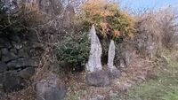
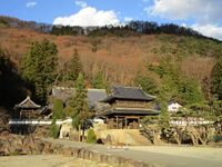
SakurasawaToride01.JPG

There is a semi-circular stone wall half way up the ridge here known as Sakurasawa-toride. 'Toride' refers to a small fort. I was quite confused because the bailey is only very small, and there is no protection to the rear. I climbed further up the ridge but there's no obvious ruins up here, although it does flatten out somewhat before sweeping further up. The wall, or parapet, seems partially formed through piling, but also partially cut into bare rock. There is some terracing toward the bottom of the ridge, but this may not be related to the fort. The site is very mysterious. Due to its small scale, the fort was likely only an observation post.
 
Shioda Castle / 塩田城

Shiodajou (1).JPG

I spent basically the whole day exploring a single castle complex, the ruins of Shioda Castle. Shiodajō is the largest pre-proto-modern castle in Shinano (Nagano Prefecture), but even so I hadn't realised just how much time and energy climbing it would take to fully explore. I am confident, however, that, after a couple of missteps, I missed no part of the site - or at least no known part of it. I would have to guess that I am the first foreigner to explore the whole thing, but there's no way to know that. Whilst Shiodajō is fairly well known locally, the site as a whole is not well represented, and many visitors to the castle ruins, even to their uppermost peak, probably only explore half of it at the most.

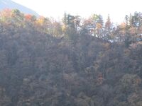
Shioda is called locally 'the Kamakura of Shinshū' due to the concentration of splendid temples throughout the valley, a product of its historic prosperity. At its centre Shioda had a large castle. Or, rather, a castle complex with a series of fortifications built over several ridges of a mountain. These fortified ridges cradled the castle proper in the steep valley between them.

I had already been to Shiodajō before, but only what proved to be a small part of it. At that time I wrote that the castle has an upper and lower part. This is true in a sense, but the upper castle was actually series of forts and fortified peaks along the ridges. One could further distinguish an upper and lower part of the castle proper, as the most secure area, and today the site of its most impressive ruins in terms of remaining structures, is narrower and nestled snugly between two ridgetop forts, the West Fort and East Fort.

The forts of Shiodajō which together constituted a vast fortress are numerous, but the three main ones, from which smaller fortified areas radiate out from, are the Nishi-toride (West Fort), Higashi-toride (East Fort), and Kōbōyama-toride, the latter also called "Upper Shioda Castle" as it is the highest situated on the mountain peak. The well defined Nishi-toride is on a terminus of the west ridge, and above it are the lower reaches of the Upper Castle which are referred to as its central or middle forts. The Upper Castle further has western and eastern fort groups. The eastern fort group spans the eastern ridge and connects with the Higashi-toride which functions as the main node in that branch of the fortress. It should be noted that distinct from these forts and the rest of the Upper Castle, as well as the West Fort, is the 'grouping of westerly forts' which spread onto an entirely different ridge to ensconce another valley, now the site of the temple Ryūkōin, which neighbours the main castle / Lower Castle. Although the western fort group links up with the western branch of the Upper Castle, they are separated by a severe and abrupt change in elevation - well, a cliff, I suppose.

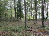
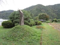
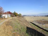
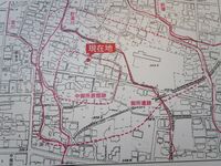
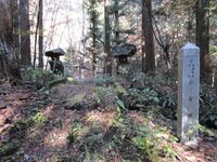
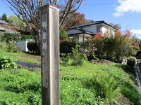
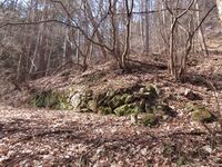
As for the castle proper, I will detail its features below. The Lower Castle of Shioda is a valley castle composed of a series of terraces. The site can be divided into three parts, the outer, middle and inner (these are my divisions). The outer castle ruins are indistinct as they are now the site of various rice paddies and orchards covering hillside terraces. The middle ruins begin where the tarmac road turns down hill, and there is a large stele here which proclaims the site. From here the ruins become more distinct, and include karabori (dry moats), dorui (earthen ramparts) and tatebori (climbing moats). The terracing here is bold and spacious, and the terraces are tall. Various residences would've stood here. An impressive segment of dorui runs opposite the old stele. Beneath the stele are the remains of a karabori.

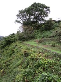
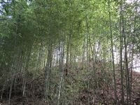
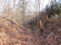
The inner castle, which I define as the area being flanked by the ridgetop forts above, starts at the point where there is now an information board. There is also a fence here to keep out / in wildlife. In my previous visit this was as far as I ventured as that day was dedicated to visiting temples. The inner castle is much narrower, on average about half the width of the lower sections. Terraced baileys are located either side of the Ôte (main path). At the top of the Ôte, or at least before it bends, is something that looks like an old tomb or storage space, a structure of earth and masonry, though it is also shown on maps as a well. I haven't seen a well dug into a slope rather than straight down before. Behind the Mishima Shrine is a very large tatebori. To the left are four smaller tatebori, but I couldn't see these due to the overgrowth and I had no desire to crawl around on the hillside looking for them. I could see some bumps and rills, and that is all. I left that section to the experts. Actually, I then saw Ranmaru-sensei wrote on his blog "if you can see four tatebori here then you are a true believer in God (Miyasaka Takeo)". Ha. I put down "unejōtatebori" as a possible feature.

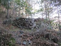
Above the shrine the inner castle becomes more claustrophobic - or cosy, depending on one's point of view - and is half the width again of the proceeding segments. The path climbs to the right and to the left are a staircase of terraced baileys. The start of this inner section of the inner castle is guarded by a tatebori to the east and a climbing section of sekirui (stonewall) to the right. The stone-piled wall has collapsed considerably but it's still obvious if one knows to look for it, and the stones were clearly piled around some sort of climbing embankment. This is a very interesting defensive feature but probably many visitors miss it.

It is from here that we find Shiodajō's most salient features, its ishigaki (stone-piled ramparts), koguchi (gate complex), and ido (well). The 'tiger's maw' gate with its ishigaki is amazing considering its age. Although bits of masonry can be found here and there about the Lower Castle, the blocks here were most sturdily applied. The shape of the gate complex, forcing angled turns, is easy to appreciate. To the rear of this gate area is a stone-lined well. When I interrogated its depth with my camera flash I saw that there was a puddle at the bottom and a hardhat. Luckily it appears that there was no head in the helmet when it fell down. Several terraces climb beyond this gate area, and from here paths lead to the various forts of the Upper Castle and beyond.

For other parts of this fortress see:

Shioda Yakata

Shioda Nishi Fort

Shioda Koubouyama Fort

Shioda Higashi Fort

Shioda Nishibouruigun
 
Shirasawa Fort / 白沢砦

ShirasawaToride02.JPG

Shirasawa-toride was an unanticipated castle site visit for me. I was going between Ogiwarajō and my next planned site, Oshinojō, and suddenly I felt a disturbance in the force. Given the low-lying, mostly flat and long mountain I was going on, I didn't wonder if it wouldn't make sense that there weren't more fortification sites along it between the two. So I checked and there was. Maybe I'm developing extra-sensory perception when it comes to castle sites? Haha. I was worried I'd have to back-track to reach Shirasawa-toride as I'd passed it at a lower elevation, but I chanced a road going up which ended up curving back and getting me quite close to my target. Lucky! If so, my luck ended there. The site was covered in fallen trees, strangling ivy and nasty thorny plants. Those lecherous plants tugged at me as I tried to demurely pass. Anyway, they got my bear bell. I only realised when I heard howling in the woods below me (though probably just a monkey). At the fort site I identified at least one bailey, probably two, and what looked like should've been a trench, so it wasn't a total loss.
 
Tanokuchi Jin'ya / 田野口陣屋

TanoguchiJin'ya02.JPG

The site is now fields but the town's old regulations board can be seen here, though it is empty now. For related sites see Tatsuoka Castle and Taguchi Castle.
 
Tekozuka Castle / 手子塚城

Tekodzukajou.JPG

Essentially this castle ruin is now a shrine, but remains include earthworks such as trenches, embankments and baileys. Though I could make them out it was difficult to photograph these. I presume the main bailey is where the shrine is. In front of the shrine a large fox was sitting. At first I thought it might be a dog due to its size. When it spotted me it got up and silently fled. I was impressed with the encounter; do these canids cavort with the gods at dusk?
 
Teshiro Castle / 天城城

Teshirojou01.JPG

Teshirojō is a lonely, small site, consisting of a main bailey and some subsidiary enclosures. It was built on a kofun (there are lots of kofun in the mountains here) which has its burial chamber now uncovered. This is apparently a power spot. Maybe all of Japan should be declared a power spot? I found an unmarked kofun by myself in trying to find more remains of Teshirojō.
 
Uede Yashiki / 上手屋敷

UedaYashiki03.JPG

This yashiki / yakata (fortified manor house) site in the town of Akashina is now just fields and schools. However, Unryūji is a temple linked to the yashiki, and that can be found nearby; it has several important buildings dating to the Edo Period.
 
Wada Castle (Ina) / 伊那和田城

InaWadajou01.JPG

I could find no identifying ruins of Ina-Wadajō. I came here as part of a tour of faux castle structures. Tôyama Town Museum, also known as "Wada Castle", is the main attraction, and is built in the general shape of a castle tower. The structure, opened in 1990, should properly be considered a "castle-inspired structure" rather than a serious reconstruction attempt - similar to Komakijō's "keep"! Next to the museum building is the temple Ryūenji which was the site of the Wadajō's main bailey. Tôyama-gō (遠山郷) is apparently on the list of the most one hundred secluded regions in Japan (日本の秘境100選).
 
Yamabe Yakata / 山家館

YamabeYakata (4).JPG

The former fortified residence of the Yamabe Clan is now Tokūnji ('Benevolent Cloud Temple'). The former yakata site is located at the foot of the western ridge that leads to Yamabe Castle, a yamajiro (mountain castle). There is some hiking to do between the two sites, although the lower reaches of Yamabe Castle reach about half way to the temple, along the western ridge. Before one reaches Yamabe Castle there is a shrine. The temple anyway is nice. It has a signboard which recaps the history of the area and of the temple from medieval times, but doesn't specifically mention the yakata, just that it was at the center of the base of operations of the Yamabe Clan. Yamabe Castle is accessed along the western ridge via the temple's necropolis. The gate between the cemetery and the temple garden has a sign which says 'Deer will not be admitted for prayer', and so the gate is kept closed on the latch. The hondō's roof is copper plated, presumably to preserve the thatching underneath.
 
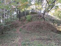
Yamabukiyama Noroshidai / 山吹山烽火台

YamabukiyamaNoroshidai01.JPG

Yamabukiyama-noroshidai is a noroshidai (fortified beacon tower) site in the Hiyoshi area of Kiso Township, Kiso County.

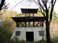
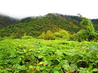
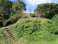
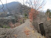
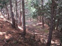
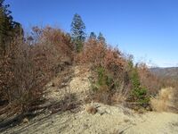
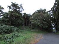
Every August 14th the Rapposho Festival in commemoration of Kiso Yoshinaka takes place in Miyanokoshi. Villagers gather and children lead a torch-lit procession from Tokuon Temple to the top of Mount Yamabuki where there is a cleared space high up on the mountainside. Here the torches are arranged in a 「木」 shape, lighting up the mountain with the ideograph. The trail to this site is well maintained for this purpose, though the climb itself is not trivial. Beyond the festival site is the ruin of Yamabukiyama-noroshidai, a signal fort. I was surprised to find here a three-storey mock reconstruction of a watch tower. The tower is falling to pieces, however, making ascending it a risky prospect. I did, of course, and there are views of the valley below to be had from there.

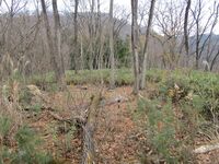
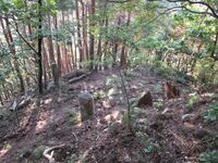
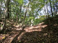
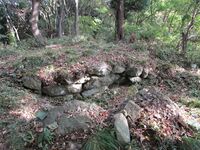
The fort's ruins consists of earthworks, such as dry moats, trenches and baileys. The main part of the fort is bounded by two trenches, which can still be seen clearly today; one is spanned by a short bridge and the one in the rear requires a short hop down into. These are each approached by sloped areas, redolent of former terracing. These trenches would've been much deeper originally, of course. Although now hard to see except from below the bailey, the main bailey is divided by a pair of dorui (earthen ramparts) with a trench between them that cuts into the main enclosure, creating a barrier which requires a diverted approach, though these earthworks are very deformed now and easy to miss. Short dorui can also be found toward the rear of the central enclosure.
 
Yashiro Castle / 屋代城

Yashirojou01.JPG

The ruins of Yashirojō are located on a small mountain overlooking the temple Manshōji. The mount gradually declines until it recedes into the northern plain. Earthworks, such as trenches and terraced pocket baileys, can be found right the way down the mount, starting from just above the plain. The main bailey is located at the very top. Features include karabori (dry moats), kuruwa (baileys), and dorui (earthen ramparts).
 
Yoda Yakata / 依田館

YodaNobushigeYakataHanshouin03.JPG

Yoda-yakata is located at the foot of the castle-mount of Taguchijō and is now the site of the temple Banshōin. I came here because I had intended to climb the trail behind Banshōin to Taguchijō, a yamajiro which is largely visited for the view it provides of Tatsuokajō, the star-shaped bastion fort. However, landslides destroyed the trail earlier this year, so I had to abandon that plan and instead visited several temples in the area instead.
 
Yoshioka Castle (Ina) / 伊那吉岡城

InaYoshiokajou10.JPG

Ina-Yoshiokajō is of modest size with impressive trenches set amidst low-lying foothills in the village of Shimojō. It is now a park (honmaru (main bailey)), orchards (ninokuruwa (second bailey)), and a shrine (tonokuruwa (hall bailey)), amongst other things. Formerly there was also a large outer bailey. A busy road runs deep where a trench used to be between the main and second baileys, spanned by a modern bridge called honmarubashi which leads into the castle park, which has some modern - but okay looking - ishigaki. Apparently a gate from the castle has been relocated to a nearby residence, but this is on private property.
Loading map...


0
Loading comments...