34 new profiles from ART for Shizuoka and Yamanashi
34 new profiles from ART for Shizuoka and Yamanashi
2025-07-08
Aika Yashiki / 秋鹿屋敷
Amagata Castle / 天方城
Baba Noroshidai / 馬場烽火台
Chouja Yashiki (Totomi) / 遠江長者屋敷

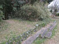
The dorui is is 100m long east to west, and 60m long north to south, forming a rectangular enclosure. The dorui is 10m wide at its base, 3m wide on top, and 3m tall. There is an additional row of smaller dorui in front of the entrance to the compound, forming a sort of rudimentary barbican where the moat is spanned by an earthen bridge.
Something very curious about this site is that the moats are on the inside of the ramparts rather than the outside. Earth excavated for moats is usually piled toward the bailey, not away from it. However, this did remind me of some jōsaku sites, a type of fortification from the same period as the Chōja-yashiki. I think it's also quite interesting that there is a large kofun (ancient burial mound) complex nearby, and so the place was likely considered one of importance when choosing a location to govern from even after the transition from Kofun to Asuka and Nara periods.Choukokuji Fort / 長谷寺砦
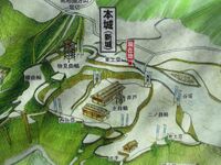
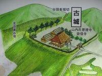
Furujiro Fort / 古城砦
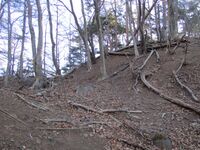
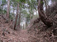
To reach this site I first descended via the ridge which climbs on beyond Daizōkyōjiyama. From that peak it takes about half an hour to march to the pass with the signpost pointing down the mountain toward Chōkokuji. Furujiro is located about half-way down that route which cuts through several old forest roads.
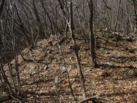
By the way, that part of the mountain above the fort site had been ravaged by a forest fire the month prior, which unexpectedly smouldered for about a month starting after the new year. Patches of ground, logs and the bases of trees here and there were blackened in dark and rueful patches, and even the log steps on the trail down from the pass got charred. It was fascinating to see how the slow-moving fire had crawled up and over the mountain, seemingly jumping in places, and still strongly carried the aroma of ash.Goudo Noroshidai / 神戸烽火台
Hakii Castle / 波木井城
Hakii Yakata / 波木井館
Now the site is open fields and cedar groves. I climbed past the field with the hokora up an old mountain path hemmed in on both sides. Another open field is located here with a pylon in it. Further up the mountain ridge is terraced in sweeping bands, and this area is a large cedar plantation. A large creek separates two ridges, each flattened atop and terraced. I followed the creek up and got the impression that it may have been augmented by medieval hands as a large climbing trench -- owing to the condition of the ridges and the persistent depth of the upper part of the creek as it rose -- but this may just be fancy. This area would've been readily defensible at any rate.
The religious monuments on the hillside are related to the nearby Nichiren temple of Kyōenbō. The sculpted hillside may also owe, in addition to the possibility of fortifications, to an extension of the temple, or to agricultural pursuits in later times. Ruins at this site are suggestive but ultimately mysterious.Iida Castle (Totomi) / 遠江飯田城
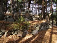
The main bailey and second bailey, divided by a small terrace, are surrounded by tall, wide dorui. In the northeast the dorui broadens into a sub-bailey serving as a look-out platform.
Several ridges of the hill are also protected with horikiri (trenches) and berms. Several terraced sub-baileys are also found around the hillside; I saw a fox in one (this site is decently maintained but most visitors likely don't bother with the smaller baileys, inviting wildlife).
Note: This site is Iidajō in Tôtōmi Province (Shizuoka Prefecture), not to be confused with Iidajō in Shinano Province (Nagano Prefecture).Iidako Castle (Totomi) / 遠江飯田古城
Jissouji Yakata / 実相寺館
Kagohana Fort / 籠鼻砦
Koteshiro Fort / 小手城砦
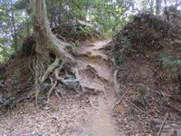
Incidentally, this site is difficult to find and dangerous to reach. My hat goes off to the gentleman(?) blogger at Kojōshi-Tanbō whose shoulders I stand on. He identified the location of the site on his blog and described how he failed to reach it from three different routes. As such, I decided my only chance was to climb up above the ridge and then descend to reach the fort site.
In the morning I first climbed to a related fort ruin on the peak of Daizōkyōjiyama, Niijiro ('New Castle'), which is the main fort site in the group of three obscure fort sites including Furujiro ('Old Castle') and Koteshiro ('Branch Castle'). This took over an hour from the trailhead along the direct route up the rocky ridge. From there it takes about an hour (I dawdled to inspect the forest fire damage along the ridge above Daizōkyōjiyama so maybe it needn't take that long) to the next major peak, Fukakusasan ('Deep Grass Mountain'). I descended along a trailless ridge from that peak to find Koteshiro.
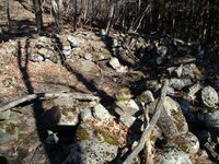
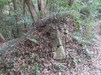
Koteshiro contains no obvious fortification ruins but there is a single fascinating structure. A large pile of masonry is found just above a somewhat flat portion of the ridge. This pile of collapsed masonry is hollowed in the middle, forming a pit. My first thought was that it was a far flung kofun (ancient burial mound) as there are other kofun lower down the mountain. However, I could find no burial chamber nor the large stones that would be needed as vaulting for the shaft and entrance. I wondered, instead, if I wasn't looking at the shambolic remains of a furnace or pit used for sending smoke signals and light beacons -- a noroshidai (beacon platform). However, it is for me indeterminable.
I was glad to find something for my trouble. Beneath the fort site is a cedar plantation. A net fence was used to damarcate the private land, but the forest fire a month prior to my trek damaged the net in many places, causing the plastic to curl up, and old trees to collapse onto and flatten it. The winter forest fire began after new year and smouldered for about a month above Mount Daizōkyōji, so parts of the forest in this area are blackened and sooty. I would recommend this off-trial site only to the most romantically inclined.Koumyo Castle / 光明城
Maenoyama Noroshidai / 前の山烽火台
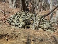
The forest road which begins opposite Shiokawa Shrine goes by a curious stone-piled tomb-like structure dug into the hillside, but with a tiny entrance, and so unlike a kofun (ancient burial mound). I scrambled up to have a look inside but there was no clue within the space inside, large relative to the entrance. At first I had no idea of the purpose of this stone-lined dug-out, but then it dawned on me: it looked like a charcoal kiln! This would've been necessary for sending smoke signals from the noroshidai above. These may be the chief medieval remains at this site then; very exciting.
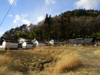
The forest road terminates at a set of rickety scaffolding stairs leading to the mountaintop. The reason for this infrastructure is to grant access to the antenna in the bailey. Speaking of infrastructure, the mountaintop overlooks Lake Mizugaki, an artificial lake created by the Shiokawa ('Salt River') Dam which dams the Shio River. The view of the lake and the dam is excellent from the noroshidai site. The mountainside facing the dam has been intensively fortified - albeit with modern concrete retaining walls to prevent any slippage. This whole scene was quite intense, especially in the chill winter air.Majino Castle (Kai) / 甲斐真篠城
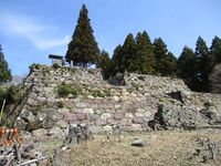
Majinojō is a principally earthworks fort with features typical of yamajiro such as kuruwa (baileys), dorui (earthen ramparts) and trenches. It is built to a sizable scale, with tall and thick ramparts, multiple baileys, and several gate complexes.
The layout of the fort is concentric with a dominant main bailey on the hilltop, surrounded by impressive dorui. The hillside is terraced below into sub-baileys. To the east is a projecting bailey with a dobashi (earthen bridge) and karabori (dry moat) complex. To the north is a tatebori (climbing moat) and nobori-dorui (climbing earthen ramparts) carved from a ridge spur. The approach to the fort is alongside a little southward, and it seems this is where the fort's kyokan (residential annex) used to be, and this area is terraced today but it's since been cultivated and is now a cedar plantation.
To the south the fort has three layers of terraced baileys, with some castle-bloggers indicating masonry remains in the corner of the second bailey - facing the third. However, I think this may be natural rock. But I made my own discovery: just below here is what appears to be a tatebori, and this wasn't shown on the map I was using (by Yogo-sensei).
Majinojō has a prominent southern spur, and this is where can be found it's most unique feature. A ten-deep row of undulating berms and trenches. Usually unejōtatebori (climbing trench array) complexes cover the mountainside, but at Majinojō one rises onto the ridge and creates a formidable array of lateral trenches. These ten rows of lateral trenches gradually rise, so defenders could presumably fire over their companions from them. This innovative configuration of trenches and ramparts is not seen anywhere else quite like this, and is very special, which may be in part why Majinojō is a prefectural-level designated historical site.Minagawa Jin'ya (Totomi) / 遠江皆川陣屋
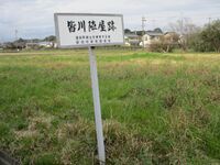
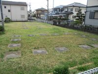
Nakaizumi Jin'ya / 中泉陣屋
Niijiro Fort / 新城砦
Niijiro-toride is paired with Furujiro-toride ('Old Castle Fort') on the same mountain. There is even a third, more obscure site called Koteshiro-toride ('Branch Fort'). By the way, I'm adding the suffix 'toride', meaning 'fort', to these names, though they are often listed without. 'Shiro' means 'castle' so it may be considered redundant to add a suffix, but these sites all have generic names which many other sites share elsewhere, even within Yamanashi. I hope the addition of 'toride' clarifies that 'shiro' is part of the reading and name of each of these sites, and not a suffix itself. Besides which, all of these sites are very minor and obscure.
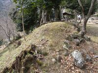
Niijiro has some defnitive castle ruins, and is the main fort in its group. The peak is lopsided though parts appear to have been worked somewhat, perhaps to create a shallow terrace. Frankly, it doesn't look like a bailey. However, to the rear is a berm and trench system. This trench unmistakably indicates a fortification, and it is not a small trench either. Niijiro was likely just served as a noroshidai (beacon tower), but the rear trench is surprising at such a site.Noji Castle / 野地城
The main bailey area is now a local park, and there is a raised plot overlooking the lakeshore where a shrine used to stand. There is a large mound with an altar on which could've served as some sort of platform. To the rear of this mound is what looks like a moat site, or pass, from which the piled earth was excavated, or so I fancied.
Most of the moats at this site, of which several segments remain, are horrendously overgrown, but a relatively clear stretch of karabori (dry moat) can be seen in a field just to the east of the park. The remnants of other dry moats cut into the fields here and there, but are mostly choked with vegetation. Particularly in the south there appears to be the remains of a ringing moat system. The second bailey moat is partially visible, having been cleared of overgrowth.
The Hamana Lake Cycle Road wraps around the western half of the site. In the eastern half of the site there is a large berm with a long pond bent at a clean angle beneath it. I estimate the length of the long portion of this pond to be about 40-50m. It really looks like a mizubori (water moat), perhaps some remnant of a larger moat system which cut the small peninsula on which the castle sits off from the mainland. It wasn't depicted on the map I was using, but would correspond to the outermost moat around the third bailey, the southern portion of which remains as a karabori.
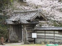
At a nearby temple, Makayaji, my castle senses tingled when I saw the temple's sanmon (main gate), which looked like a castle gate. I checked and it turned out to be a relocated gate from Nojijō. Of course, I should've researched that beforehand instead of relying on any sixth sense, but it was a happy discovery.Ohwatari Noroshidai / 大渡烽火台
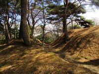
Ôwatari-noroshidai overlooks the Torii Pass, where there is no torii, but there is a Kannon statue. The ridge above the pass starts off steep, and then gradually evens out before the castle ruins become clear in the form of the terracing of the ridge. Bands of terraced baileys march up the ridge to the fort's main bailey. The main bailey is long and narrow, surrounded on three sides by dorui (earthen ramparts). The southern side has no parapet wall. To the rear of the main bailey is a horikiri (trench). There is a row of hokora (mini-shrines) in the middle of the bailey.
The dorui was heaped up as a process of flattening the ridge to create the main bailey, but below the dorui the mountainside is incredibly steep in any case. If one goes beyond the rear horikiri the ridge is quite narrow, and it terminates in a part of the hill overlooking the steep mountainside. Below the Shiokawa bends around the castle-mount, providing a natural barrier on three sides. Whilst many noroshidai consist only of singular baileys, this single bailey fort complex is impressive owing to the rugged terrain and relative isolation.Sakaime Castle / 境目城
Saku Castle / 佐久城
The fort is small but well constructed. There is a main bailey with a koguchi (tiger's maw gate) ruin, and an outer umadashi (barbican) connected to the honmaru (main bailey) by a dobashi (earthen bridge). There is what looks like an expanded creek facing inland between the honmaru and umadashi, and on the lake-facing side there is a complex of trenches and berms in an impressive array. These trenches slope down the hill, and so they are tatebori (climbing trenches), with dorui in between.
Because the entrance to the site, maintained as sort of park, also appears like a trench, and there is some flat terrain beyond, it is thought that the castle also had an outer bailey of some sort, but the structure of the fort is not clear in this section.
Note: This site is also sometimes called Mikkabi-Sakujō.Sanadayama Castle / 真田山城
The path up to this ruin has moved in recent years, as has a signboard for the castle. There used to be a footbridge over the Ichinomiya River near to a tea shop with a giant teapot outside, but it was washed away in a typhoon. I found another bridge - more of a plank - by taking a riverside path to the south of the castle-mount. The trail is not long, but is fun; there are more rickety bridges over creeks. It is not clear whether the trails are still maintained, but I got up okay despite discouragement from the lady at the tea shop.
Note: Though some sources refer to this site as 'Sanadajō', there appears to be no relation to the Sanada Clan of Shinano.Sentougamine Castle / 千頭峯城
Shimizu Nuidonosuke Yashiki / 清水縫殿助屋敷
Shimoyama Castle (Kai) / 甲斐下山城
Shizuhatayama Castle / 賤機山城
Shizuhatayamajō may be considered the medieval antecedent of the proto-modern Sunpujō on the plain below. Shizuhata is thought to have given its name to Shizuoka, but the kanji for 'shizu' was changed from 賤 ('sleazy') to 静 ('tranquil'), the latter being much more auspicious (when the modern city was founded in 1889, other name proposals included 'Shizu(静)' and 'Shizuki(静城)'; the original settlements had consisted of the jōkamachi (castle-town) of Sunpu (駿府) and the shukuba (inn town) of Fuchū (府中)).
The trail up Mount Shizuhata starts at the Sengen shrine at the foot of the mountain. The trail is maintained with park-like features and so is pleasant to walk. It doesn't become a serious mountain trail until the castle ruins.Suganuma Castle (Kai) / 甲斐菅沼城
Utsuyama Castle / 宇津山城
The eastern portion of the castle is made up of a series of baileys separated by dry moats and embankments. I first tried to enter into one of the baileys above the road to the western castle, but it was too choked with bamboo to make progress. Next I tried to take a dirt road up past a house, itself thought to be built on a former bailey, and I made it into an outer bailey which was surrounded by dorui. The bailey itself was full of abandoned greenhouses. The second bailey was seriously overgrown and the path was blocked with fallen trees. I could barely see the otherside of the bailey due to pest plants so, having already visited the western castle at this point, I stopped my explorations here. Clearly the site was formerly cultivated and is now abandoned and heavily overgrown.
The western castle is the more interesting of the two halves. The road up to the castle is maintained because the cemetery of the temple below, Shōtaiji (presumed site of the castle's kyokan (living area)), was built on the terraced sub-baileys which climb the hillside to the castle proper. Behind the necropolis is a large dorui segment. A map displayed on-site indicated a tatebori (climbing trench) somewhere beneath here, but I think it must be lower down on the slope.
The most intriguing feature of Utsuyamajō may be the ishigaki which supports the inside of the dorui which surrounds the main bailey of the western fortress. Usually we'd expect to find ishigaki on the outside of the bailey to create steep walls, but in Utsuyamajō's case the outside of the bailey's ramparts is earthen, whilst the inside has a 1.2m high wall of stacked stones like a retaining wall. It is believed that this wall was made by the castle-builders so that they could stand behind the parapet whilst firing guns and cannon, and that there was no dobei (parapet wall) with loopholes as we'd expect to see. The ishigaki actually replaces the dobei in this case!
I tried to follow the parapet all the way around the main bailey but most of the site is horrendously overgrown with a botanical tangle of various plants. I also descended down the far side of the main bailey where there are large terraces in a tripple band. Ishigaki can be found here too. I wasn't sure if these terraces and their retaining walls were originally part of the castle or built for agriculture.
There were so many spiders at this ruin that I was constantly assailed by threads of sticky web no matter where I turned. Even recollecting my exploration here makes me feel itchy. A woman who I thought might be visiting the cemetery actually came from the direction of the main bailey covered in sticky seeds, and she warned how hopelessly overgrown the bailey was. Even though this site gets visitors attracted by the ishigaki, and it is designated as a historical site by the municipality, it's in an awful condition, and I wish it could be better maintained.Recent News
Sep 28, 2025
Yagyu Castles, Chihaya Akasaka Forts, and Kaibara Jin'ya
Sep 20, 2025
ART added 33 new castles across central Japan
Jul 29, 2025
31 new profiles from ART for Gifu Prefecture
Jul 19, 2025
Battle of Shizugatake Feature + 17 new castles
Jul 8, 2025
34 new profiles from ART for Shizuoka and Yamanashi
Jun 7, 2025
Comment System Upgrade
May 24, 2025
Four new castles around Sasayama Hyogo
May 16, 2025
10 Kyoto Castles Update May 2025
Mar 23, 2025
Hagi Castle & Hagi Castle Town Project
Jan 23, 2025
Bitchu Matsuyama Castle and Ohmatsuyama Castle Updates
Jan 3, 2025
2024 Jcastle cleanup and Happy New Year 2025
Dec 10, 2024
Sayonara Google Maps
Dec 2, 2024
Tsuyama Castle Update and 500th Castle Visited
Nov 11, 2024
Jcastle Rebuild 2024
Oct 3, 2024
11 New Castles around Kyoto
Sep 30, 2024
ART's New Profiles for Aichi Prefecture
Sep 22, 2024
5 new Okinawa Castle Profiles
Jul 27, 2024
Mikazuki Jinya, Kohyama Castle, and updated Hikone Castle
Jul 22, 2024
28 new profiles from ART
Jul 7, 2024
5 Castles from Ayabe City in Kyoto