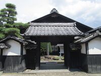
Nagano Castle Update from ART Part II
Second installment of Nagano Prefecture castles from ART.
Nagano Castle Update from ART Part II
2022/03/19
Second installment of Nagano Prefecture castles from ART.
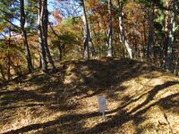
Ara Castle (Murakami Clan Fort Network) / 村上荒城
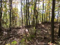
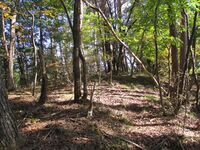
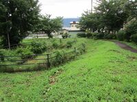
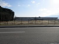
Asahi Castle (Minochi) / 水内旭城
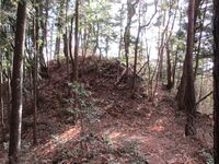
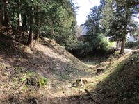
The first bailey is more standard and has a koshikuruwa (supporting bailey) beneath to the southeast, but between the first and second bailey is a huge karabori which appears to split the mountain in two. This is a piece of work to behold! Scattered around both baileys are the remnants of stone walls which would've encased the ramparts. It is suggested that the first bailey was also surrounded by dorui but that this was levelled when the shrine to Inari was built. I was surprised about how much this site offered even though it was only a satellite fortification of Asahiyamajō above. It's a wonder how many people even visit here; I missed it the first time because I had assumed Asahiyamajō and Asahijō to be one and the same site, perhaps understandably, but they're not. One should visit Asahijō too after hiking to Asahiyamajō.
The best way to go to Asahijō is via a road which leads directly to the shrine to Inari which the castle site now hosts. I ended up going around, up and past here though. Getting a little lost I came upon the abandoned village of Hirashiba. Although the area was inhabited since ancient times, I believe there is only one inhabited home left (I saw someone at a distance whacking fruit from a persimmon tree). Trying to get back on track I took an old dirt road past several abandoned homesteads, vehicles, rubbish and plots of land.
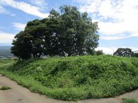
I came to a miraculous thing. It was a twin burial mound, or a single large mound with two burial chambers. As I said, this place is ancient. If you wonder that I am insensitive to how creepy sounds an abandoned village with ancient tombs yawning darkly from amidst the ruins, know I am not as scientific as all that, and although I had a sense of forboding I was morbidly drawn to explore the chambers. Well, it was just as one would expect, for inside I found the kind of Lovecraftian horror which sent Randolph Carter fleeing manically across the Big Cypress Swamp. Indeed. Cave Crickets! Giant ones with hunched, loathsome legs and throbbing stingers, scurrying on the underside of the lintel just above my head. Terrifying.Chiisagata Yashima Castle /
[[|200px|link=Chiisagata Yashima Castle]]
Hanagoya Castle (Murakami Clan Fort Network) / 村上花古屋城

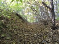
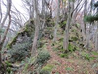
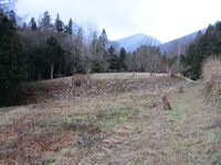
The first few baileys beneath the shukuruwa are the most impressive. Because they are large their terraces are necessarily tall. The ridge starts to flatten out beneath them, but even so there are many more horikiri (trenches), kuruwa (baileys) and some dorui all along the ridge almost to the bottom. I lost count of the number of horikiri.
To reach Hanagoyajō I continued to ascend from Arajō toward Mount Tarō. I thought the way from Ushibusejō up to Arajō had been quite steep but the climb between the Tarō shrine and Arajō is twice as steep again! Or nearly so. This was taxing me somewhat so I didn’t go all the way to the peak, despite its friendly name, and instead when I found where the ridge lines connected I immediately descended again. Descending this ridge from Mount Tarō brings one to Hanagoyajō which sits on the ridge opposite from Ushibusejō and Arajō. There is no trail down off the mountain except from just at the back of the shukuruwa, and so, since I didn't want to climb all the way back up there, I took myself off the mountain via the unorthodox conveyance of sliding down through the leaves. It was like riding a toboggan! I caught myself once or twice on a helpful tree after sliding too quickly, and when I came to the end of the ridge I lowered myself down on a vine. I got dirty no doubt but it was a lot of fun.Iizuna Castle (Murakami Clan Fort Network) / 村上飯綱城
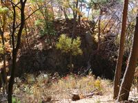
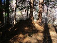
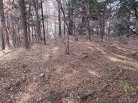
Iiźunajō has four principal baileys. To the rear is the fourth, with two considerable trenches one after the other protecting its rear. Beneath the fourth is the first or main bailey complex, and it has three parts to it, an upper, middle and lower. The upper is separated by a terrace from the middle, and the middle from the lower by dorui (earthen ramparts). On either side of the lower portion, which contains a well ruin, are climbing trenches down the sides of the bailey.
The site’s most impressive sight is the large double trench system between the first and second bailey. Dorui is piled between two dry moats, and the trench on the side of the second bailey, which is situated above on its own small peak, is very deep, having been cut into the rock. This formidable arrangement, a solid stone wall hewn from the mountain itself, would’ve been deadly to attackers. The second bailey has dorui atop, and even some ishigaki (stone-piled rampart) remains.
Between the second and third bailey is yet another double trench system. Once again bare rock has been exposed and cut into, forming defences out of the body of the mountain. The third bailey complex is made up of an integral bailey and many sub-baileys beneath it which terrace the elevation. These terraces continue down the ridge continually and are interspersed with a fourth and final double trench system, and then a single lone trench before the castle’s precincts gradually taper off.
Iiźunajō can be accessed via two different routes. I took the route from the “former helipad”, now a parking area for hikers, which goes by old fields with stone-lined terracing up to a point on the ridge at the top of the castle site. The route that descends from there could also be taken from the bottom up. I got to the old helipad site by climbing up from Mochikoshijō to the Rabbit Pass, and them coming down again. The Rabbit Pass is the site of a humungous boulder which stands tall on the ridgeline which runs up to Mount Kokuzō. Climbing to this point rewarded me with stunning views. Probably though it would’ve been easier to go back to the bottom of the mountain from Mochikoshijō and re-ascend to get to Iiźunajō. Needless to say I regret nothing, though the hike down from the Rabbit Pass to the “heliport” was grueling. The steep sections lined with ropes meant that I basically went down the mountain backwards whilst clutching the ropes like an abseiler. At one point I gave myself too much slack and fell with my buttock right onto a cut stump a few inches across, which smarted, though a bottle of tea in my back pocket may have dulled much of the blow. My bear bell is still up there somewhere between the ropes. Then there came a series of interminable switchbacks beaten into a cascade of loose rocks which poured from some point far up the mountainside like a lava flow. In comparison to this the trail from the heliport to the castle ruins was a doddle.Kitsuneyashiki Yakata / 狐屋敷館
Kokuzousan Noroshidai / 虚空蔵山烽火台
Komiyama Yakata / 小宮山館
Kouji Yakata / 越氏館

Koyamura Yashiki / 小屋村屋敷

Kurahone Castle / 鞍骨城

Kuruma Castle / 来馬城
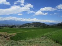
The road goes to a weather station which is also a park. One can park a vehicle here, and there are toilets. The park has a viewing platform which gives one a view similar to the one the caslte mount would've before it was covered in trees. Kurumajō was built on a hill at a bend in the Himekawa, being bounded by the river on the north, east and south, and joining up with mountains to the west. To the southwest flows the Urakawa. It has been intersected with countless huge wiers of concrete to prevent river-borne landslides. The river and mountains seem to rise up into a vast, grey skydome, with hints of wintry peaks beyond. This is the site of the Great Hieda Landslide, or the "Collapse of Mount Hieda (稗田山崩れ)", one of the "Three Great Landslides of Japan (日本三大崩れ)".
Although the exact cause is unknown, it is said that heavy rain four days prior instigated the collapse of Hieda in 1911. The scale of the landslide was incredible. The northwest summit of the mountain collapsed, burying the Urukawa and blocking the Himekawa. Earth and rock flowed like liquid around the ruins of Kurumajō. Kuruma village below was innundated and destroyed, and dozens of people lost their lives. Mountain detritus was cast as far as 6km and the valley floor was raised up to 100m at the landslide's deepest point. The natural damming caused a large lake to form. When the dam became waterlogged surviving residents tried desperately to drain it, but the earth inevitably collapsed again, leading to flooding down stream. The landslide buried many homes and left fertile fields barren. The Kita-Otari municipal hall was swept away. Fish in the river died en masse. Life became untenable and the valley was depopulated. To this day the area is heavily managed by the Ministry of Land, Infrastructure and Transport (Kokudokōtsu-shō), and corridors of otherwise cultivatable land are given over to nature. The ruins of Kurumajō oversaw the destruction from high ground, avoiding obliteration.
Matsugaminejō is another name for Kurumajō but one source lists a Matsugaminejō as a separate site located on the north side of Kuruma village, rather than the south, where there is a smaller but similar (to Kurumajō) projection of earth at a bend in the Himekawa. It's opposite Kita-Otari Station on the west side of the Himekawa. I had intended to check it out on my way back to the station but whilst I was at Kurumajō it had started raining and the rain became quite heavy thereafter, and so I did not climb the hill to check for evidence of fortification. I went past the hill but saw no obvious route up or signposts. It may have to remain a mystery.Machimura Fort / 町村砦

Michikusa Fort / 道草砦
Mochikoshi Castle (Murakami Clan Fort Network) / 村上持越城
Momose Yashiki / 百瀬屋敷

Myogiyama Noroshidai / 妙義山烽火台・妙義山狼煙台

Nabebuta Castle / 鍋蓋城
Nabeyamajou Fort / 鍋山城砦
Nakagayahori Yashiki / 中萱堀屋敷
Nakata Yashiki / 中田屋敷
Nakayama Fort / 中山砦
Nakayamaniyama Fort / 中山二山砦

It doesn't take long to climb from the north of Nakayama to the southern peak; about forty-five minutes up and half that down. The climb is not steep. The northern extreme of the mountain terminates in the Kōbōyama-kofun, a tumulus of times so ancient that mystery obscures them. This kofun (ancient burial mound) is known locally as a premier cherry blossom site. The most famous kofun are huge artificial hills built on the plains, but in Nagano somewhat more compact kofun were built atop of mountains. The mountains themselves became tombs. My walk started here. Climbing the ridge, there are remains of "flag mounds", a type of burial mound, here and there. I thought I crossed at least three. One had an irregular depression at the top which made me think that the sarcophagus within had been removed from there. The eternal sleep of some great rice baron, no doubt, didn't last so long after all.
The climbing elevation picks up here though not too dramatically. I made it to peak 774 easily enough. The experts say a fort used to be here. Now, the ridge line between the fort has been altered through landslides, and the area of the fort itself has also been eaten into by these mountainous movements. Ruins have been obscurred by the movements of the earth, though there is a suggestion of an emabnkment around a portion of the wide, flattened area at the peak. The fact that this peak is so flat is itself the greatest testament to its former fortification. I imagined a gate ruin where the ridge continued on, and that's as far as I could really put together for this one. A ridge spur descends from the fort eastward, and I checked a little along here but didn't see anything noteworthy. Nor did I find any trenchwork along the ridge. After this I continued up to Nakayama-toride, or Nakayama Fort I.Narai Castle / 奈良井城
Natsumichi Fort / 夏道砦
Nezumiana Castle / 鼠穴城
Nezumiana Yakata / 鼠穴館
Nirekubo Yakata / 楡窪館
Nomura Fort / 野村砦
Nomura Yakata / 野村館
Nyunomi Castle / 丹生子城
Odatsuno Yakata / 小立野館
Odoriba Fort / 踊場砦
Ohmachi Kitahara Yakata / 大町北原館

Ohmachi Minamihara Yakata / 大町南原館
Ohmiyahachiman Yakata / 大宮八幡館
Ohmura Yakata / 大村館
Ohtaridaira Yakata / 大足平館
Okada Chikayoshi Yakata / 岡田親義館

Onikuma Yakata / 鬼熊館
Onjouyama Fort / 御城山砦

Oyobiki Yakata / 及木館
Tsubame Castle (Murakami Clan Fort Network) / 村上燕城
Ushibuse Castle (Murakami Clan Fort Network) / 村上牛伏城

Yomogidaira Castle (Minochi) / 水内蓬平城
Recent News
Sep 28, 2025
Yagyu Castles, Chihaya Akasaka Forts, and Kaibara Jin'ya
Sep 20, 2025
ART added 33 new castles across central Japan
Jul 29, 2025
31 new profiles from ART for Gifu Prefecture
Jul 19, 2025
Battle of Shizugatake Feature + 17 new castles
Jul 8, 2025
34 new profiles from ART for Shizuoka and Yamanashi
Jun 7, 2025
Comment System Upgrade
May 24, 2025
Four new castles around Sasayama Hyogo
May 16, 2025
10 Kyoto Castles Update May 2025
Mar 23, 2025
Hagi Castle & Hagi Castle Town Project
Jan 23, 2025
Bitchu Matsuyama Castle and Ohmatsuyama Castle Updates
Jan 3, 2025
2024 Jcastle cleanup and Happy New Year 2025
Dec 10, 2024
Sayonara Google Maps
Dec 2, 2024
Tsuyama Castle Update and 500th Castle Visited
Nov 11, 2024
Jcastle Rebuild 2024
Oct 3, 2024
11 New Castles around Kyoto
Sep 30, 2024
ART's New Profiles for Aichi Prefecture
Sep 22, 2024
5 new Okinawa Castle Profiles
Jul 27, 2024
Mikazuki Jinya, Kohyama Castle, and updated Hikone Castle
Jul 22, 2024
28 new profiles from ART
Jul 7, 2024
5 Castles from Ayabe City in Kyoto